And what is the name of the shortest parallel. What are parallels and meridians in geography? Questions and tasks
Almost all of you have paid attention to the "mysterious lines" on maps and globes representing latitude (parallels) and longitude (meridians)... They form a gridded coordinate system by which any place on Earth can be pinpointed - and there is nothing mysterious or complicated about it. Parallels and meridians are imaginary lines on the surface of the Earth, and latitude and longitude are their coordinates, which determine the position of points on the surface of the Earth. Any point on Earth is the intersection of a parallel and a meridian with latitude and longitude coordinates. This can be most clearly studied with the help of a globe, where these lines are indicated.
But first, everything is in order. Two places on Earth are determined by its rotation around its own axis - this is North and South Poles... On globes, the pivot is the axis. The North Pole is located in the Arctic Ocean, which is covered with sea ice, and researchers in the olden days reached this pole on a sleigh with dogs (it is officially believed that the North Pole was discovered in 1909 by American Robert Perry). However, since the ice moves slowly, the North Pole is not an actual object, but rather a mathematical object. The South Pole, on the other side of the planet, has a permanent physical location on the continent of Antarctica, which was also discovered by land explorers (Norwegian expedition led by Roald Amundsen in 1911).
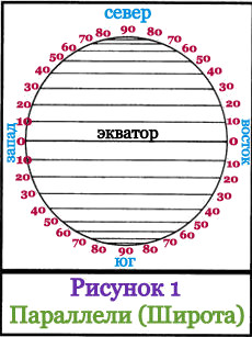 Halfway between the poles, at the "waist" of the Earth, there is a large circle line, which is represented on the globe as a seam: the junction of the northern and southern hemispheres; this circle line is called - equator... The equator is a line of latitude with a zero value (0 °). Parallel to the equator, above and below it, other lines of the circle are located - these are other latitudes of the Earth. Each latitude has a numerical value, and the scale of these values is measured not in kilometers, but in degrees north and south from the equator to the poles. The poles are: North + 90 °, and South -90 °. Latitudes located above the equator are called northern latitudes, and below the equator - southern latitudes... Lines with degrees of latitude are called parallels, since they run parallel to the Equator and are parallel to each other. If parallels are measured in kilometers, then the lengths of different parallels will be different - they increase as they approach the equator and decrease towards the poles. All points of one parallel have the same latitude, but different longitudes (the description of longitude is just below). The distance between two parallels, which differ by 1 °, is 111.11 km. On the globe, as well as on many maps, the distance (interval) from latitude to another latitude is usually 15 ° (this is about 1,666 km). In Figure 1, the interval is 10 ° (this is approximately 1,111 km). The Equator is the longest parallel, its length is 40,075.7 km.
The need to accurately determine the location of one's own and surrounding objects on the earth's surface has become especially relevant for a person with the beginning of an active exploration of the planet.
Geographic coordinates - latitude and longitude - are determined by the intersection point of two imaginary lines - the parallel and the meridian. The longest parallel from which the latitude starts is the equator.
origin of name
An imaginary line, which is formed into points located at the same distance from both poles, divides the planet into two hemispheres, two hemispheres. The word for the name of such a border has ancient roots. Latin "aequator", equalizer, is derived from the verb "aequō" - to equalize. In international practice, "equator" came from the German language, from Äquator.
This word also has a more general meaning. In geometry, a three-dimensional body, which has both a mutually perpendicular axis and a plane of symmetry, has its own equator, its longest parallel - the intersection of the surface of this body with the plane of symmetry. In astronomy, the celestial equator, the magnetic equator of a planet or star are known.
The earth is a geoid
The belief that the Earth has the shape of a flat disk was questioned only by ancient Greek scientists. By the end of the 19th century, it became clear that the shape of our planet is not just an ideal ball, but a special body of revolution - a geoid, the surface of which is influenced by many factors - from the force of gravity to the "cosmic wind". Two points of the geoid are determined by the axis of its rotation - these are the North and South Poles. At an equal distance from them is the longest parallel on Earth, the earth's "waist" - the equator.

But the geoid does not accurately, but only approximately describes the shape of the planet. Such it would be in the absence of mountains and depressions, if there were only a calm, undisturbed surface of the world's oceans. This level plays an important role in navigation and geodesy - it records vertical elevations for various technical and engineering objects.
Equator length
It is possible to understand which parallel is the longest by the specific values of the geoid's geometrical measurements. The radius of the equator, as a circle "drawn" on the surface of the Earth, is equal to the radius of the planet. Accurate measurements show that this parameter differs in different parts of the planet - the polar radius is 21.3 km less than the equatorial one. Average value - 6371 km
Using the formula for the circumference of a circle - 2πR - you can calculate the length of the equator. Different geophysical standards define figures with a difference of about 3 m, on average - 40,075 km. along the meridian - 40,007 km, which proves the special geometric qualities of the geoid.
Zero latitude
The coordinate grid that covers the globe - a visual model of the globe - is formed by 360 meridians connecting the two poles, and 180 lines parallel to the equator, distributed 90 pieces to the poles, on either side of it. The origin of longitude since 1884 is considered to be the meridian drawn through the English capital located in the southeast. The longest parallel, dividing into the Northern and Southern Hemispheres, is the origin of latitude.

Coordinates are angular values, measured in degrees. Longitude - the angle between the plane passing through the zero - Greenwich - meridian and the one that is indicated by the line connecting the earth's poles and drawn through a given point. To the east of Greenwich up to 180 °, longitude is called east and is considered positive, to the west - it has negative values and is called west.
Points equidistant from the poles form the equatorial plane. The radius drawn from the center of the globe through a given point on its surface forms an angle with this plane, the magnitude of which is latitude. The longest parallel is latitude zero. North of the equator, this angle is considered positive - from 0 ° to 90 °, to the south - negative.
Signs and rituals
The equator is only an illusory border of two hemispheres, but it has always excited the human imagination. It is customary for sailors from different countries to observe special rituals when crossing zero latitude, especially in relation to those who do it for the first time. Where the equator passes inhabited places, special signs and structures are invariably erected to make the conventional line real. A rare tourist will miss the opportunity to stand with one foot in the South, and with the other in. It is impossible to forget after that, as the longest parallel of the globe is called.

But the equatorial zones of the Earth also have other unique characteristics that give them special value. The gravitational attraction here is slightly less than in other latitudes, and the momentum of the globe's rotation is greater. This allows significant savings for launching spacecraft into orbit. It is no coincidence that it is in equatorial French Guiana, on the South American coast that the most efficient launch space complex is located - the Kourou cosmodrome.
A) 1 B) 2 C) 3 D) 4
2. What are the coordinates of the easternmost point in Africa?
A) 16 ° S 3 ° East
B) 10 ° N 51 ° East
B) 51 ° N 11 east longitude
D) 16 ° N 3 ° W
3. What type of climate is shaded on the map?
A) Subequatorial
B) Tropical desert
C) Tropical wet
D) Equatorial
4. Which country is indicated on the map with a contour line?
A) Congo
B) Egypt
C) Somalia
D) Ethiopia
5. What conclusion about the climate of Africa is fashionable to draw on the basis of the fact that the continent is crossed by the equator and both tropics?
A) Africa receives a lot of heat all year round
B) Africa is in the zone of the trade winds
C) Africa has tropical and equatorial climatic zones
D) All of the above conclusions
6. What researcher made a great contribution to the study of Africa - discovered Victoria Falls, studied Lake Nyasa?
A) Vasco da Gama B) V.V. Juncker C) D. Livingston D) N.I. Vavilov
7. What is located north of the East African Plateau?
A) Cape Mountains B) Drakensberg Mountains C) Kilimanjaro Volcano D) Ethiopian Highlands
8. In southern and eastern Africa more than in North Africa:
A) Oil B) Phosphorites C) Uranium ores D) Gas
9. In the subequatorial belt of the Northern Hemisphere in Africa, precipitation falls:
A) Throughout the year B) in the summer C) In the winter D) In September and March
10. In the tropical latitudes of southern Africa along the east coast more precipitation falls than along the west, because there:
A) moist equatorial air masses act
B) the cold current cools the air and promotes the formation of precipitation
C) In the summer in the southern hemisphere there are monsoons
D) Trade winds bring humid air from the Indian Ocean
11. The most full-flowing river in Africa, full-flowing throughout the year, does not form a delta, these are:
A) Nile, B) Congo C) Zambezi D) Niger
12. Which lake in Africa is the deepest?
A) Victoria B) Nyasa C) Tanganyika D) Chad
13. What plant or animal is not typical for the savannah zone?
A) Hippo B) Gorilla C) Acacia D) Baobab
14. What peoples live in northern Africa?
A) Arab peoples B) Bushmen C) Negroids D) Pygmies
15. Which country in Africa is the largest in terms of population?
A) Egypt
B) South Africa
C) Algeria
D) Nigeria
determine the geographic latitude of Paris, Mexico City and the Panama Canal.
3. On the map of the hemispheres, determine the geographical coordinates of St. Petersburg, Cape Town and Lake Chad.
4. On the physical map of Ukraine, determine the geographical coordinates of the regional center of your region. (Donetsk)
5. By geographic coordinates, determine the objects on the map of the hemispheres:
a) the highest waterfall in the world 6 N, 61 W;
b) an island that has several names: Rapa-Nui, Vaigu, but on the map it is designated under a different name - 27 N, 109 W; + c) an object that in 1856. discovered by the American traveler David Livingston-18 N, 26 c, d.
The globe is a model of the globe... It clearly shows how the oceans, continents and other geographic objects are located. On the globe, the same scale is maintained in all directions, and therefore the image is more accurate than on the map.
The scale must be indicated on the globe or map. It shows the degree of reduction in the size of objects and the distances between them in comparison with the true dimensions and distances on the ground. For example, a scale of 1: 50,000,000 (one fifty millionth) means that the reduction is 50 million times, that is, 1 cm on a globe or map corresponds to 500 km on the ground.
But globes have a major drawback: they are always small in scale. If we wanted to make a globe of the same scale as a physical map (1: 5000,000, that is, in 1 cm - 50 km), then its diameter would be almost 2.5 m. Using such a globe is inconvenient.
1. Modern globe. 2. Examples of scales. 3. The surface of the globe, cut into stripes along the meridians: distortions are inevitable on a map drawn up in this way.

Distances on the globe are determined using a flexible ruler, a strip of paper or thread.
On ordinary school globes, it is impossible to depict small details in the outlines of the continents, in the structure of the river network, mountain ranges, etc. Many states (for example, Denmark, Belgium, Portugal) are depicted with such small figures that they barely have enough space for one circle - the symbol of the capital. Therefore, geographical maps are created, on which a part of the earth's surface is depicted on a scale larger than on a globe.
If you look at the globe, you can see many thin lines on it. Some run from top to bottom from the North Pole to the South and are called meridians. On the globe and on maps, they indicate north and south directions. Other lines, perpendicular to the meridians, seem to encircle the globe. These are parallels. On maps and the globe, they determine the direction to the west and east. The parallels are not equal in length. The longest parallel is the equator, the shortest are located near the poles.

1-2. Meridians and parallels are conventional lines on the globe and map. 3. Degree network. 4. Determination of directions "north - south" along the meridian. 5. Determination of directions "west - east" in parallel.

Both parallels and meridians are conditional lines. They are needed in order to determine the location of geographic objects by geographic coordinates.
Questions and tasks
- What is a Globe?
- How is it different from a card? Find in the text of the paragraph the answer to the question: what is the main advantage of a globe over a geographic map?
- For what purpose is the scale indicated on the globe and map?
- What are parallels and meridians for?
- Explain the geographical meaning of the word "navigate".
- Have you ever wondered what geographic feature is located in the other hemisphere in a place diametrically opposite to where your city is? Find it on the globe and describe it according to the plan:
- what he really is;
- what is the name of;
- where it is located: in what climatic and time zones it is located, what geographic objects are in the neighborhood.
- Find the intersection of the equator and prime meridian.
- Select from the list the characteristic features of the parallels:
- have the shape of a circle;
- drawn from pole to pole;
- they determine the direction "west - east";
- all the same length.
The points of intersection of the earth's axis with the surface of the globe are called the poles (North and South). Around this axis, the Earth makes one revolution in 24 hours.
A circle is drawn at the same distance from the poles, which is called the equator.
Parallel - lines conventionally drawn along the surface of the Earth parallel to the equator. The parallels on the map and globe are directed west and east. They are not equal in length. The longest parallel is the equator. Equator - an imaginary line on the earth's surface, obtained by mentally cutting an ellipsoid into two equal parts (Northern and Southern hemispheres). With such a cut, all points of the equator are equidistant from the poles. The equatorial plane is perpendicular to the Earth's axis of rotation and passes through its center. In total, there are 180 meridians on Earth, 90 of them north of the equator, 90 - south.
The parallels between latitudes 23.5 ° north and south are called tropical circles or simply tropics. On each of them, once a year, the midday Sun is at its zenith, that is, the sun's rays fall vertically.
Parallels 66.5 ° north and south latitude are called polar circles.
Circles are drawn through the North and South poles, meridians are the shortest lines conventionally drawn on the surface of the Earth from one pole to another.
The prime or prime meridian is drawn from the Greenwich Observatory (London, UK). All meridians have the same length and semicircular shape. In total, there are 360 meridians on Earth, 180 to the west of the zero, 180 to the east. The meridians on the map and on the globe are directed from north to south.
To accurately determine the location of any object on the earth's surface, one line of the equator is not enough. Therefore, the hemispheres are mentally separated by many more planes parallel to the plane of the equator - these are parallels. All of them, like the equatorial plane, are perpendicular to the planet's axis of rotation. You can draw as many parallels as you like, but usually they are drawn at intervals of 10-20 °. Parallels are always oriented from west to east. The circumference of parallels decreases from the equator to the poles. At the equator, it is the largest, and at the poles it is equal to zero:
Length of arcs of parallels
|
Parallels |
Length 1 ° in km |
When imaginary planes cross the earth's axis, passing through the earth's axis perpendicular to the equatorial plane, large circles are formed - meridians. Translated into Russian, the word "meridian" means "midday line". Indeed, their direction coincides with the direction of the shadows from objects at noon. If you walk all the time in the direction of this shadow, then you will definitely come to the North Pole. Meridians are the shortest line, conventionally drawn from one pole to the other. All meridians are semicircles. They can be drawn through any point on the surface of the Earth. They all intersect at the points of the poles. The meridians are oriented from north to south. The average arc length of 1 ° meridian is calculated as follows:
40,008.5 km: 360 ° = 111 km
The length of all meridians is the same. The direction of the local meridian at any point can be determined at noon by the shadow of any object. In the Northern Hemisphere, the end of the shadow always shows the direction to the north, in the Southern Hemisphere - to the south.
The image of the lines of meridians and parallels on the globe and geographical maps is called a degree grid.
Geographic latitude is the distance of any point on the earth's surface north or south of the equator, expressed in degrees. Latitude is north (if the point is located north of the equator) and south (if south of it).
Geographic longitude is the distance of any point on the earth's surface from the prime meridian, expressed in degrees. To the east of the prime meridian there will be east longitude (abbreviated: e), to the west - west (w).
Geographic coordinates - geographic latitude and geographic longitude of a given object.