The biggest wave on earth. Killer waves: about the biggest wave. ... And other killer waves
At the end of December 2004, near the island of Sumatra, located in the Indian Ocean, one of the strongest earthquakes occurred in the last half century. Its consequences turned out to be catastrophic: due to the displacement of the lithospheric plates, a huge rift was formed, and a large amount of water rose from the ocean floor, which, at a speed of one kilometer per hour, began a rapid movement throughout the Indian Ocean.
As a result, thirteen countries were affected, about a million people were left without a "roof over their heads", and more than two hundred thousand died or disappeared. This disaster turned out to be the worst in the history of mankind.
Tsunamis are long and high waves that appear as a result of a sharp displacement of the lithospheric plates of the ocean floor during underwater or coastal earthquakes (the length of the shaft is from 150 to 300 km). Unlike ordinary waves that appear as a result of the impact on the water surface of a strong wind (for example, a storm), a tsunami wave affects the water from the bottom to the surface of the ocean, which is why even low water can often lead to disasters.
Interestingly, for ships in the ocean at this time, these waves are not dangerous: most of the agitated water is in its bowels, the depth of which is several kilometers - and therefore the height of the waves above the water surface is from 0.1 to 5 meters. Approaching the coast, the rear part of the wave catches up with the front one, which at this time slows down slightly, grows to a height of 10 to 50 meters (the deeper the ocean, the larger the ridge) and a crest appears on it.
It should be borne in mind that the advancing shaft develops the highest speed in the Pacific Ocean (it ranges from 650 to 800 km / h). As for the average speed of most waves, it ranges from 400 to 500 km / h, but cases have been recorded when they accelerated to a speed of a thousand kilometers (the speed usually increases after the passage of a wave over a deep-sea trench).


Before hitting the coast, the water suddenly and quickly departs from the coastline, exposing the bottom (the further it recedes, the higher the wave will be). If people do not know about the approaching element, instead of going as far from the coast as possible, on the contrary, they run to collect shells or to pick up fish that did not have time to go to sea. And literally a few minutes later, the wave that arrived here at great speed does not leave them the slightest chance to be saved.
It should be borne in mind that if a wave rolls on the coast from the opposite side of the ocean, then the water does not always recede.
Ultimately, a huge mass of water floods the entire coastal line and goes inland for a distance of 2 to 4 km, destroying buildings, roads, moorings and leads to the death of people and animals. In front of the shaft, clearing the way for the water, there is always an air shock wave, which literally blows up buildings and structures in its path.
It is interesting that this deadly natural phenomenon consists of several shafts, and the first wave is far from the largest: it only wets the coast, reducing the resistance for the following shafts, which often do not come immediately, and with an interval of two to three hours. The fatal mistake of people is their return to the shore after the departure of the first swoop.
Reasons for education
One of the main reasons for the displacement of lithospheric plates (in 85% of cases) is underwater earthquakes, during which one part of the bottom rises and the other goes down. As a result, the ocean surface begins to oscillate vertically, trying to return to the initial level, forming waves. It is worth noting that underwater earthquakes do not always lead to the formation of tsunamis: only those where the source is located at a short distance from the ocean floor, and the shaking was not less than seven points.
The reasons for the formation of the tsunami are quite different. The main ones are underwater landslides, which, depending on the steepness of the continental slope, are able to overcome huge distances - from 4 to 11 km strictly vertically (depending on the depth of the ocean or gorge) and up to 2.5 km - if the surface is slightly inclined.


Large waves can cause huge objects to fall into the water - rocks or blocks of ice. So, the largest tsunami in the world, the height of which exceeded five hundred meters, was recorded in Alaska, in the state of Lituya, when, as a result of a strong earthquake, a landslide came down from the mountains - and 30 million cubic meters of stones and ice fell into the bay.
Volcanic eruptions can also be attributed to the main causes of tsunamis (about 5%). During strong volcanic explosions, waves are formed, and water instantly fills the vacated space inside the volcano, as a result of which a huge shaft forms and begins its path.
For example, during the eruption of the Indonesian volcano Krakatoa at the end of the XIX century. The "killer wave" destroyed about 5 thousand sea vessels and caused the death of 36 thousand people.
In addition to the above, experts identify two more possible causes of the tsunami. First of all, this is human activity. So, for example, the Americans in the middle of the last century made an underwater atomic explosion at a depth of sixty meters, causing a wave about 29 meters high, however, it did not last long and fell, breaking 300 meters as much as possible.
Another reason for the formation of a tsunami is the fall into the ocean of meteorites with a diameter of more than 1 km (the impact of which has sufficient force to cause a natural disaster). According to one of the versions of scientists, several thousand years ago, it was meteorites that caused the strongest waves, which became the causes of the largest climatic disasters in the history of our planet.
Classification
When classifying tsunamis, scientists take into account a sufficient number of factors of their occurrence, among which are meteorological cataclysms, explosions, and even ebbs and flows, while the list includes low waves with a height of about 10 cm.
By shaft strength
The strength of the shaft is measured, taking into account its maximum height, as well as how catastrophic it caused and, according to the international IIDA scale, 15 categories are distinguished, from -5 to +10 (the more victims, the higher the category).
By intensity
In terms of intensity, "killer waves" are divided into six points, which make it possible to characterize the consequences of the elements:
- Waves with a category of one point are so small that they are recorded only by instruments (most of them are not even aware of their presence).
- Two-point waves are capable of insignificantly flooding the coast, therefore, only specialists can distinguish them from the oscillations of ordinary waves.
- The waves, which are classified as three-point, are strong enough to throw small boats on the coast.
- Four-point waves can not only wash large sea vessels ashore, but also throw them on the coast.
- Five-point waves are already acquiring the scale of a catastrophe. They are able to destroy low buildings, wooden buildings, and lead to human casualties.
- As for the six-point waves, the waves rushing to the coast completely devastate it, along with the adjacent lands.
By the number of victims
According to the number of deaths, there are five groups of this dangerous phenomenon. The first includes situations where no fatalities have been recorded. The second - the waves that led to the death of up to fifty people. Shafts belonging to the third category cause death from fifty to one hundred people. The fourth category includes "killer waves" that killed between a hundred and a thousand people.


The consequences of a tsunami belonging to the fifth category are catastrophic, since they entail the death of more than a thousand people. Usually, such disasters are characteristic of the water area of \u200b\u200bthe world's deepest ocean, the Pacific, but they often occur in other parts of the planet. This applies to the disasters in 2004 near Indonesia and 2011 in Japan (25 thousand deaths). “Killer waves” have been recorded in history as well in Europe, for example, in the middle of the 18th century, a thirty-meter ridge collapsed on the coast of Portugal (during this disaster, from 30 to 60 thousand people died).
Economic damage
As for the economic damage, it is measured in US dollars and calculated, taking into account the costs that must be allocated for the restoration of destroyed infrastructure (lost property and destroyed houses are not counted, because they are related to the country's social expenses).
Economists distinguish five groups in terms of losses. The first category includes waves that did not cause much harm, the second - with losses of up to $ 1 million, the third - up to $ 5 million, and the fourth - up to $ 25 million.
The damage from the waves related to the fifth group exceeds 25 million. For example, the two worst natural disasters that occurred in 2004 near Indonesia and in 2011 in Japan amounted to about $ 250 billion. It is also worth considering the environmental factor, since the waves, which caused the death of 25 thousand people, damaged a nuclear power plant in Japan, causing an accident.
Natural disaster identification systems
Unfortunately, "rogue waves" often appear so unexpectedly and move at such a high speed that it is extremely difficult to determine their appearance, and therefore seismologists often do not cope with the task assigned to them.


Basically, disaster prevention systems are based on seismic data processing: if there is a suspicion that an earthquake will have a magnitude of more than seven points, and its source will be on the oceanic (sea) bottom, then all countries that are at risk receive warnings about the approach of huge waves.
Unfortunately, the 2004 disaster happened because almost all of the neighboring countries did not have an identification system. Despite the fact that about seven hours elapsed between the earthquake and the surging shaft, the population was not warned of the impending disaster.
To determine the presence of dangerous waves in the open ocean, scientists use special hydrostatic pressure sensors that transmit data to a satellite, which allows them to fairly accurately determine the time of their arrival at a particular point.
How to survive during a disaster
If it so happens that you find yourself in an area where there is a high probability of the occurrence of deadly waves, be sure to remember to follow the forecasts of seismologists and remember all the warning signals of an impending disaster. It is also necessary to find out the boundaries of the most dangerous zones and about the shortest roads along which you can leave the dangerous territory.
If you hear the warning signal for approaching water, you should immediately leave the danger area. Experts will not be able to say exactly how much time there is for the evacuation: maybe a couple of minutes or several hours. If you do not have time to leave the area and live in a multi-storey building, then you need to go up to the last floors, closing all windows and doors.
But if you are in a one- or two-story house, you need to immediately leave it and run to a tall building or climb any hill (in extreme cases, you can climb a tree and hold onto it tightly). If it so happened that you did not have time to leave the dangerous place and ended up in the water, you need to try to get rid of shoes and wet clothes and try to catch on floating objects.
When the first wave subsides, it is necessary to leave the dangerous area, since the next one will most likely come after it. You can return only when there are no waves for about three or four hours. Once at home, check walls and floors for cracks, gas leaks, and electrical conditions.
The giant waves are called tsunamis. They are of enormous height and width, arising in the ocean under the influence of water (most often due to earthquakes). The word itself comes from the Japanese language, where it consists of two characters - "wave" and "bay". It was Japan and other countries with access to the Pacific Ocean that became victims of killer waves. The Pacific region witnessed a wave in the world that hit the coast of American Alaska.
Top 1. Tsunami in Lituya Bay, 1958
Lituya Bay is located in the northeastern part of the Gulf of Alaska. The bay is separated from the outlet to the ocean by a strait about 500 meters wide. The length of the Lituya Bay is about 11 kilometers and the width is about 3 kilometers. Cenotaph Island is located in the center of the bay.
The catastrophe was provoked by an earthquake on July 9, 1958. It caused a rockfall on the Gilbert Glacier, northeast of the bay. About 30 million cubic meters of rock and ice fell into the eastern part of the bay from a height of about 900 meters. A tsunami caused by a rockfall hit both shores of the bay and Cenotaph Island. Scythe La Gaussi, located near the epicenter of the wave, was almost completely washed away. The wave height was 524 meters. The tsunami uprooted most of the trees in the passage area.
Five people became victims of the huge wave. Two of them were caught by a tsunami on a fishing boat. The people who went out to the bay on that fateful day on two more ships miraculously survived and were picked up by rescuers.
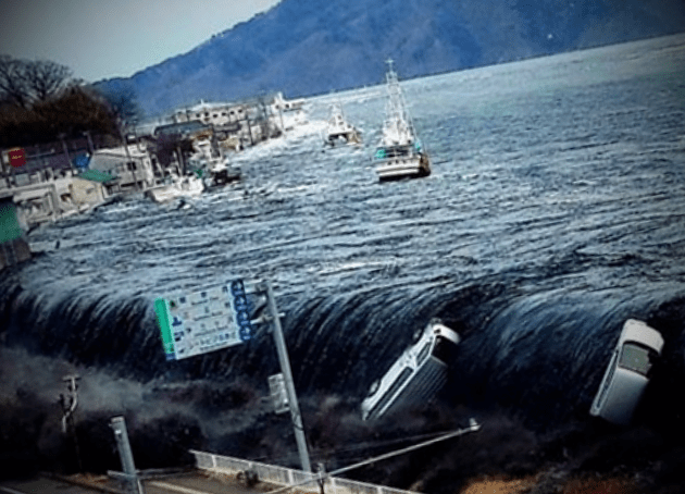
Top 2. Indian Ocean, 2004
The 2004 tsunami went down in history as the deadliest - more than 230 thousand people became victims of the anger of nature. The giant wave began with an underwater earthquake of magnitude 9. Tsunami waves hitting land reached a height of thirty meters.
Radar satellites recorded an underwater tsunami, whose height after the earthquake was about 60 centimeters. Unfortunately, these observations could not help prevent a catastrophe, because it took several hours to process the data.
Sea waves reached the coasts of different countries at different times. The first blow immediately after the earthquake struck the north of Sumatra. The tsunami reached Sri Lanka and India only after an hour and a half. Two hours later, the waves hit the shores of Thailand.
Tsunami waves led to human casualties in the countries of East Africa: Somalia, Kenya, Tanzania. Sixteen hours later, the waves reached the town of Struisbaa on the coast of South Africa. A little later, tidal waves up to a meter high were recorded in the area of \u200b\u200bthe Japanese scientific station in Antarctica.
Part of the tsunami's energy escaped into the Pacific Ocean, where tidal waves were recorded on the coast of Canada, British Columbia, Mexico. In some places, their height reached 2 and a half meters, which exceeded the waves recorded off the coast of some countries located closer to the epicenter.
Most affected by the tsunami:
- Indonesia. Three waves hit the northern part of Sumatra less than half an hour after the earthquake. According to survivors, the waves were higher than the houses.
- Andaman and Nicobar Islands (India), where more than 4 thousand people died.
- Sri Lanka. The waves reached a height of 12 meters. The passenger train "Queen of the Sea Coast" became the victim of the tsunami. His death became the largest railway disaster in modern history and claimed more than 1,700 lives.
- Thailand. Waves, the height of which was second only to those that struck Sumatra, destroyed the southwestern coast of the country. There were many tourists from other countries at the scene of the tragedy. More than three thousand people died and another five thousand are missing.
Top 3. Japan, 2011
In March 2011, an underwater earthquake struck the ocean east of Honshu Island. It triggered a tsunami that devastated the coast of Honshu and other islands in the archipelago. The waves reached the opposite shore of the Pacific Ocean. In the coastal areas of South American countries, an evacuation was announced, but the waves did not pose a big threat.
The waves reached the islands of the Kuril ridge. The Emergencies Ministry evacuated several thousand Russian citizens from the coastal areas of the islands. Near the village of Malokurilskoye, waves up to three meters high were recorded.
The first tsunami waves hit the Japanese archipelago within half an hour after the end. The highest elevation was recorded near the city of Miyako (north of Honshu) - 40 meters. The coast took the heaviest blows within an hour after the earthquake.
The tsunami damaged three Japanese prefectures in Honshu. The cataclysm also provoked an accident at the nuclear power plant. The city of Rikuzentakata was actually washed into the ocean - almost all the buildings went under water. The tragedy of 2011 claimed the lives of more than 15 thousand inhabitants of the Japanese archipelago.
Probably, the low population of Alaska was the reason why the largest wave in the world did not lead to mass casualties. Today, the earthquake and tsunami observation system has been improved, which helps to reduce the number of victims during disasters. But coastal residents are still at risk from the unpredictable ocean behavior.
There is a place in the world from which photo and video reports about giant waves are often made. Over the past few years, records in Big Wave surfing for the largest wave taken (both with hands and with a jet) have been set on the same wave of Nazare. The first such record was set by Hawaiian surfer Garrett McNamara in 2011 - the wave height was 24 meters. Then, in 2013, he broke his record by riding a 30-meter wave.
Why is it in this place that the largest waves in the world?
Let's first recall the mechanism of wave formation:

So, everything starts far, far away in the ocean, where strong winds blow and storms rage. As we know from the school geography course, the wind blows from an area with high pressure to an area of \u200b\u200blow pressure. In the ocean, these areas are separated by many kilometers, so the wind blows over a very large area of \u200b\u200bthe ocean, transferring some of its energy to the water through friction. Where this happens, the ocean is more like a bubbling soup - have you ever seen a storm at sea? There is about the same, only the scale is larger. There are small and large waves, all interspersed, superimposed on each other. However, the energy of water also does not stand still, but moves in a certain direction.
Due to the fact that the ocean is very, very large, and waves of different sizes move at different speeds, during the time until all this seething porridge reaches the shore, it is "sifted", some small waves add up to others into large ones, others, on the contrary, mutually destroyed. As a result, what is called the Groung Swell comes to the shore - smooth ridges of waves, divided into sets from three to nine with very large intervals of calm between them.

However, not every swell is destined to become the waves of surfing. Although, it would be more correct to say - not everywhere. In order for a wave to be caught, it must break in a certain way. Wave formation for surfing depends on the structure of the bottom in the coastal area. The ocean is very deep, so the mass of water moves evenly, but as it approaches the coast, the depth begins to decrease, and the water that moves closer to the bottom, in the absence of another outlet, begins to rise to the surface, thereby raising waves. In the place where the depth, or rather shallowness, reaches a critical value, the rising wave can no longer become larger and breaks down. The place where this happens is called the lineup, and this is where surfers sit, waiting for a suitable wave.
The waveform directly depends on the shape of the bottom: the sharper it becomes shallow, the sharper the wave. Usually the sharpest and even trumpeting waves are born where the elevation change is almost instantaneous, for example, at the bottom of a huge rock or the beginning of a reef plateau.
Photo 2. 
Where the drop is gradual and the bottom is sandy, the waves are gentler and slower. These waves are best suited for learning to surf, which is why all surf schools conduct their first beginner lessons on sandy beaches.
Photo 3. 
Of course, there are also other factors that affect the waves, for example, the same wind: it can improve or degrade the quality of the waves depending on the direction. In addition, there are so-called wind swells, these are waves that do not have time to "sift" by distance, since the storm is raging not so far from the coast.
So, now about the highest waves. Thanks to the winds, huge energy is accumulated, which then moves towards the coast. As you get closer to the coast, the oceanic swell transforms into waves, but unlike other places on our planet, a surprise awaits him off the coast of Portugal.
Photo 4. 
The thing is that it is in the area of \u200b\u200bthe city of Nazare that the seabed is a huge canyon with a depth of 5000 meters and a length of 230 kilometers. This means that the oceanic swell does not undergo changes, but reaches, as it is, to the continent itself, falling on the coastal cliffs with all its might. Wave height is usually measured as the distance from the crest to the base (where, by the way, something like a trough is often sucked in, which increases the height compared to if it was measured at the mean sea level at a given tide height).
Photo 5. 
However, unlike such waves as Mavericks or Teahupu, on Nazar the ridge, even if it collapses, never hangs over the base, moreover, it is separated from the bottom point by about 40 meters along the horizontal axis. Due to the spatial distortion of perspective, when viewed from the front, we see a block of water 30 meters, technically, it is even larger, but this is not the height of the wave. That is, strictly speaking, Nazare is not a wave, but a water mountain, a pure oceanic swell, powerful and unpredictable.
Photo 6. 
However, the fact that Nazaré is not exactly a wave does not make this spot any less scary and dangerous. Garrett McNamara says that getting through Nazar is incredibly difficult. Usually three people help him in the water: one pulls him to the line-up on a jet, accelerates him to the wave and does not float far to see that everything is in order with the surfer. He is secured by the second jet, as well as the third one a little further away, the driver of which is watching all three. Also, near the lighthouse on a cliff, Garrett's wife stands and tells him on the radio what waves are coming and what waves you can take. On the day he set his second record, not everything went smoothly. The first driver was knocked off the jet by a wave, so the second had to pull Garrett out of the foam, and the third rushed to help the first. Everything was done clearly and quickly, so no one was hurt.
Photo 7. 
Garrett himself says the following: “Of course, all this safety net and technical devices in surfing on big waves is a kind of cheating. And in principle, you can do without them, but in this case, the chances of dying are much higher. As for me personally, since I had a wife and children, I feel more responsibility for them and fear for my life, so I go to all the technical tricks in order to most likely return home alive. "
Photo 8. 
Photo 9. 
Photo 10. 
Photo 11. 
Photo 12. 
Photo 13. 
Photo 14. 
Photo 15. 
Photo 17. 
Photo 18. 
Photo 19. 
Photo 20. 
Photo 21. 
Photo 22. 
sources
The most common cause of waves in oceans and seas is wind: gusts of air move the surface layers of water at a certain speed. So, the wind can disperse a wave at a speed of 95 km / h, the raised water column can reach 300 meters in length. Such waves are able to overcome giant distances, but, as a rule, the wave energy is extinguished in the ocean, dissipating long before land. In the event that the wind subsides, the waves in the ocean become shallower and smoother.
Patterns of wave formation
Wave length and height depend not only on wind speed. The influence and duration of wind exposure is great, and it also matters how much of the territory was covered by it. There is a logical correspondence: the maximum wave height is 1/7 of its length. For example, a breeze with a force above average forms waves, the height of which reaches 3 meters, a hurricane, which has a large area, raises waves up to about 20 meters.
Big wave formation
In 1933, sailors of the American ship "Ramapo" in the South African current of Agulhas noted the highest normal wave - it reached a height of 34 m. Waves of this height are popularly called "Killer waves", since in the distances between their crests even a large vessel can easily fail and get lost. Theoretically, the height of such ordinary waves is capable of reaching 60 m, but in practice such waves have not yet been recorded.
In addition to the normal, that is, wind origin of waves, other reasons for the generation of waves are known:
- earthquake
- eruption
- fall of large meteorites into the ocean
- landslides leading to an abrupt change in the coastline
- nuclear weapon testing or other human activity
Tsunami
Tsunamis have the largest waves. In essence, it is a serial wave caused by a certain pulse of enormous power. Tsunami waves are quite long, the dips between the peaks can reach more than 10 km. For this reason, a tsunami in the open ocean is not a big danger, since the wave height rarely reaches 20 cm, only in some (record) cases can they reach 1.5 m. But the speed of the tsunami is tremendous - the waves propagate at a speed of 800 km / h. In the open sea from a ship, such waves are almost impossible to notice. Tsunami waves acquire their monstrous strength as they approach the coastline. Reflecting from the coast, the waves are compressed in length, and their destructive energy does not disappear anywhere. As a result, the wave amplitude grows - their height. Of course, such waves are much more dangerous than wind waves, since they reach much higher heights.
The reasons for the most terrifying tsunami size are significant disturbances in the topography of the ocean floor. These can be tectonic shifts or faults, in the event of which a billion tons of water at the speed of a jet plane travels over huge distances (as much as tens of thousands of kilometers). And it happens abruptly, immediately. A catastrophe is inevitable when a multi-billion dollar mass of water reaches the shore. Then the colossal energy of the waves is first directed to build up the amplitude, and then falls on the coast with the entire powerful wall of water.
 Tsunami in Sumatra in 2004
 Bays with high shores are most often prone to dangerous tsunamis. Such places are real traps for serial waves. What is characteristic and at the same time scary is that a tsunami almost always flies in suddenly, visually the sea can be the same as during ebb, tide or an ordinary storm, so people do not even think about timely evacuation. Unfortunately, special warning systems for the approach of giant waves are not developed everywhere.
Seismically active territories are also tsunami risk zones. The word "tsunami" itself is of Japanese origin, since earthquakes are very frequent here and waves of various scales and sizes constantly attack the islands. There are real giants among them, and they lead to human casualties. The 2011 earthquake, which occurred in the east of Honshu, gave rise to a powerful tsunami up to 40 m high. Japan has never known such earthquakes. The catastrophe had horrific consequences: the monstrous power of the waves struck the strongest blows along the entire eastern coast of the island, killing over 15 thousand people along with the earthquake, several thousand people are still missing today.
A large-scale catastrophe in the islands of Java and Sumatra in 2004 turned into a tsunami, which was generated by the strongest earthquake in the Indian Ocean. According to various sources, from 200 to 300 thousand people died - this is 1/3 million. Today the tsunami in the Indian Ocean is recognized as the most destructive in the world.
The record holder in wave amplitude was tsunami "Lituya", which happened in 1958. It swept across the Lituya Bay in Alaska at a speed of 160 km / h. The cause of the world's highest tsunami was a huge landslide. Wave heights reached 524 m.
Megatsunami in Lituya Bay, Alaska, USA is the most destructive wave in the world (its length is more than 500 meters). The catastrophe occurred in 1958 on July 9. It was the largest natural disaster known to science. A little later, scientists called the phenomenon "megatsunami".
Causes of the disaster
The giant wave is caused by a magnitude 8 earthquake off the Alaska Peninsula. The tremors caused a huge landslide that threw a massive glacier and piles of rocks into the water into Gilbert Bay. It was they who became the main cause of the appearance of the giant wave.
Consequences of the disaster
Major casualties were avoided: ten fishermen died and vegetation along the coast was destroyed. The memoirs of eyewitnesses say that "the mountains trembled terribly, the stones rushed down rapidly, then suddenly they disappeared, and a giant wall of water appeared."
Presumably, similar tsunamis have occurred here before with an interval of several decades. The tsunamis that occurred were also quite high, but the trail of their impact were finally eliminated by a natural disaster in 1958.
Next Megatsunami
Megatsunami in Lituya was the first case for science when a giant wave was caused not only by an earthquake, but also by a landslide.
One of the strongest tsunamis was the aftermath of the Indian Ocean earthquake on December 26, 2004. It is the deadliest natural disaster in modern history. The devastating wave has dealt a huge blow to Thailand, Indonesia, Sri Lanka and Somalia. The capital of the Maldives, Male, was badly damaged during the tsunami. Certain areas of the city had to be rebuilt.
The death toll from the natural disaster is estimated at 235 thousand people.
Sadly, many of the victims are tourists who have taken vacations on the shores of Thailand, Indonesia and Malaysia.


