Schubert's map of the Moscow province. Calculating abandoned villages Vintage maps with detailed anchor
The history of the lost settlements that have not survived to this day is an important component of the history of the region.
Today we will tell you about the village Lipovets, which existed in the XVI-I half. XVIII centuries on the territory of the Housing Cooperative (Zhilkopa) of the urban settlement of Fryanovo, Shchelkovsky District, Moscow Region, village Gridino, at different times called Bravino, Brovkino or Gridkovo, from the beginning of the 16th to the beginning of the 20th century was located on the right bank of the Dubenka river opposite the village of Golovino, a village Kopylovo in the XVI-I half. XVIII century located between Mavrino and Stepankovo, village Lunevo, in the XVIII - the first half. XIX century. located on the right bank of the river. Melezhi near the village of Bobry and a village with an unusual name Bolokhrystovo, at the beginning of the XVI - the first half of the XIX century. which existed not far from the present Staropareyev ...

Lipovets
In Xvi century was the ancient village of Lipovets. She was listed in the estate for Ivan Mikitin's son Boskakov.
Ivan Mikitin son of Boskakov (Baskakov). The Boskakovs were relatives of the Zubovs, who from time immemorial owned the village Gridina located between and. Both families descended from the Tatar Baskak Amragat (Miragan), who was baptized with the name of Zachariah (Martyn).
One of the sons of Amragat, Parthenius, who accepted monasticism with the name Paphnutius, died in 1478 and in 1540 was canonized (Venerable Paphnutius of Borovsky, 1394-1477). His other son, Ivan Boskakov, died in the Kazan campaign in 1547. One of Baskakov's descendants, Sharap Baskakov, sold a number of his estates to the Trinity Makhrishchi Monastery, but this deal was challenged by Timofei Klobukov, the son of Toporkov, another large patrimony of the Shchelkovo Territory. The Baskakovs were among the old families of the Central Russian districts, which had long-standing contacts with representatives of the administration of the Trinity-Sergius Monastery.
Venerable Pafnuti Borovsky.
In the lists of service people, Desyatnya 1577, the owner of the village of Lipovets, Ivan Mikitin, son of Baskakov wasmarked as follows: "At the verstan the oklatchiks said: they do not know eve, they do not live from the verstan."... In other words, a servant person was not allotted land for his service, but lived at the expense of his own estates. The commentator of this mention believes that it was Ivan Mikitin Baskakov who owned the Lipovets village.
The need for money was one of the reasons that forced the owners to part with the ancestral estates. In 1577/78 Ivan Baskakov sold his large village Aleksino in the Kinelsky camp to the Trinity-Sergievsky Monastery. Despite the fact that Ivan Boskakov had a son, Evdokim Ivanovich, he gave the Lipovets village with the courtyard of the patrimonials to the Suzdal bishop's house according to his soul. Later, in 1627, Evdokim tried unsuccessfully to sue a number of ancestral estates of his father at the Trinity-Sergius Monastery. Another son of Ivan Mikitin Boskakov, Ivan, served under the command of Ivan Vasilyevich Sitsky (? -1608), the then owner of the neighboring village. In 1586, I.V. Sitsky turned Ivan Ivanovich Baskakov into 350 pieces of land in the Moscow district. It is interesting that the third son of Ivan Boskakov, Grabysh Ivanov, son of Boskakov was the nephew of the clerk Shemet Ivanov and together with him entered the possession of the future Fryanovo. The wife of Ivan Mikitin's son Boskakov was the sister of Shemet Ivanov.

So, in 1584-1586, the village of Lipovets, together with the Likhachikha (Endova) heath adjacent to the possessions of the village and the Klimushi heath (Klimushino, not far from), passed into the possession of the Suzdal bishop's house: "The village of Lipovets, which was formerly behind Ivan after Boskakov, and in it the courtyard is dominated, and Grigory Kirilov, the son of Samsonov, lives in it."... Soon the following were added to the possessions of the Suzdal bishop's house: the Klimush heath (the territory of the Fryanovskaya factory), the village of Poreevo (Staropareyevo) and the now defunct villages of Bolokhristovo and Ikonnikov (Ikonnikovskaya). The village Lipovets, being in the church domain, was abandoned in the first half - the middle of the 18th century. On the maps of the General Survey of 1766-1770, the area belonging to the College of Economy was listed as Lipovitsa wasteland.
Gridina (Bravino, Brovkino, Gridkovo)
On the right bank of the Dubenka river, opposite from the beginning Xvi century to the first half XX century there was a village that does not exist today Gridina... V Xvi century it was the ancestral domain of Ivan Zubov, descended from an old noble family, which was built to the Tatar Baskak Amragat (Miragan), who was baptized with the name of Zakhariya (Martyn) and who became the ancestor of the Zubovs and Boskakovs. The kinship of Ivan Zubov with the Boskakovs is all the more interesting because on the territory of the future Fryanovo in the possession of Ivan Boskakov there was a village Lipovitsy... In addition, the son of Boskakov was the nephew of the clerk Shemet Ivanov and together with him entered the possession of the future Fryanovo. Information about the life and work of Ivan Zubov has been lost, but it is known that until 1584-86 the village, which by that time had become a wasteland, passed into the possession of his son: "For Grigoriy Ivanov, son of Zubov, his father's old patrimony: the wasteland that was the village of Gridina" .
In 1768, the village of Gridina, named "Bravina", along with its lands, stretched to the village of Golovino, located on the other side of the Sherenka river (on the map of 1786-1791 - the river "Reshenka"), and was part of the possession of the village Golovino of the state councilor Sergei Ivanovich Protopopov.

D. Brovino on the map of 1786-1791
By 1812, the name of the village changed again. The village is called this time "Brovkino". Then the widow of Sergei Ivanovich, Anna Alekseevna Protopopova, already owns it and the village. Around 1816, the owner sells the village to the son of a famous architect, the collegiate assessor A.I. Starov, and sells the village "Gridkovo" (Brovkino) to Captain Anatoly Sergeevich Vyazemsky, who owned the village at that time. In 1852, 54 serfs lived in seven households in the village of Gridkovo. After the abolition of serfdom and the redemption of land allotments from the owner (1862), there were 8 households and 58 people. At the end of the century, due to the outflow of the population from the village to work, the number of people living in the village was decreasing. Back in 1882, the same number of people lived in the village "Grid'kova" in 7 houses as 20 years ago, but in 1890 (the same in 1899) only 20 peasants lived in the village. In the same year, 1890, at the village there was a landlord's estate, which belonged to the hereditary honorary citizen Alexandra Nikolaevna Smirnova.
After the revolution, in 1926, the village of Gridkovo (Gridina) belonged to the Dubrovinsky village council. There were 12 households here, 37 people lived. It is not known exactly when the village ceased to exist in these places. Now here nothing reminds of her, and the indefatigable waves of time have erased the memory that once lived and died here, dreamed, worked and loved our ancestors.
Kopylova (Kopyly)
It is worth mentioning another ancient village that has not survived to this day, which existed back in the days when the present village was a wasteland. Between Mavrino and, a little to the north of the also not preserved village v Xvi century was the now defunct village of Kopylova. The village got its name from the name of its most ancient owner, the patrimonial landowner, which could have been the Moscow princely mayor in Pskov, mentioned in 1510 by Yuri Kopyl (Kopylov). Geographically, the village belonged to the Vor-Korzenev stan. The village was an old patrimony of the Napolsky - large patrimonials of the Kinelsky district. Until 1573, the unserviceable son of the boyar Fyodor Teplov Napolsky took the land of the Mavrinsky Wasteland for rent. At that time, representatives of the class of landowners from the crumbling clans of boyars or boyar warriors were called "Boyar children". Until 1584/1586 the village of Kopylova was abandoned, and apparently after the death of F.T. Napolsky, passed into the possession of his sons: “For the undergrowth for the Peasant and for Ondryushka for the Fedorovs of Napolsky’s children, their old father’s patrimony is der. Kopylova, who was previously behind Fyodor Napolsky, and in her was the courtyard of the patrimonials " . In 1596 Andrei Fyodorov, son of Napolskaya, made up the local land (150 quarters) across Pereslavl Zalessky. Andrey Fedorovich was numbered as an unserviceable and helpless "novice", that is, a young man of 15-18 years old, now, in 1596, he was taking up military service. Noviks, who received land salaries this year, made up the cadres of the Time of Troubles. Together with him, the son of the owner of the Mavrino wasteland in 1630, Sidor Elizariev, was included in the “tenth of noviks”.

A century and a half later, in 1768, the Kopylov wasteland belonged to the owner of the village of Gavrilkovo - Anna Vasilyevna Eropkina, and after her it passed into the possession of the court counselor Olga Mikhailovna Potresova. In 1852, the wasteland was no longer mentioned.
Lunevo
In the old days, Lunevo was located a little west of the village on the same right bank of the river. Melezhi is slightly upstream. Unfortunately, no documents have survived that could testify to the ancient origins of this lost village. Only its name can tell us about it. Many noblemen Lunevs who owned estates are known to Russian history from the second half Xv century. Someone Philip Koptev, son of Lunev, was placed in the suburbs of Moscow by 250 children of the land of the Ten Noviks in 1596.

Seltso Lunevo on the map 1786-1791
In 1768, which became the village of Lunevo, was in the possession of Countess Yekaterina Ivanovna Karamysheva (1716- ?, nee Tolstoy) - the wife of the court councilor Nikolai Fedorovich Karamyshev. Ekaterina Ivanovna was the daughter of Count Ivan Petrovich Tolstoy (1685-1786) and Sophia Sergeevna Stroganova (1824-1852). Then 40 souls of serfs lived in the village.

In 1812, the Lunevo village was owned by the wife of a collegiate secretary, sister of the owner of the neighboring village of Bobry, Anna Karlovna Yanish. Sisters Anna and Elizabeth were the daughters of Karl Ivanovich Yanish (1776-1853), professor of medicine, one of the first rectors of the Yaroslavl Demidov Higher Sciences School, popularizer of the chemical theory of light. During Napoleon's invasion, Anna Karlovna provided 16 warriors from the serfs of the village of Lunevo to the militia. In the second quarter XIX century Lunevo falls into desolation and merges with the village of Beavers. On the Schubert map, it is already referred to as "the village of Beavers (Lunevo)". In 1852, the village was no longer mentioned.
Bolokhrystovo
In the second half Xvi For centuries, not far from Staropareyev, in the interfluve of Shirenka and Kilenka, there was an ancient patrimonial village that did not exist today, bearing a rather strange name Bolokhrystovo. In Sreznevsky's dictionary, the first part - "Bolo" is the root of the Old Slavic word "Bologo" - "good". This name of the village, indicated in the documents of 1573-1586, may indirectly testify to the antiquity of the village and the etymology of its name "Good (good) - Christ", dating back to XV century.
In the second quarter Xvi for centuries owned the village Semyon Petelin, descended from an old family of Pereyaslavl estates who served the Moscow princes since the time of Grand Duke Ivan Kalita. The most famous of the Petelin family of clerks was earned by the clerk of the Order of the Grand Palace (1578) - Druzhina Foma Panteleevich Petelin, who, according to the English diplomat Gils Fletcher, was “A very remarkable person among the natives in intelligence and quickness in political affairs ». A certain Ivan Petelin in 1450 owned villages and villages in the Kinelskaya volost, located northeast of the Trinity-Sergievsky monastery along the Pereyaslav (Trinity) road. Descendants of the Petelins - servicemen Yakov and Vaska are mentioned in the documents of the Time of Troubles. It is only known for certain that Semyon Petelin left no heirs and passed the village of Bolokhristovo by inheritance to his daughter "Mashka Semyonova's daughter Petelin", who owned it for the most part, until 1584, when, as an escheat patrimony, the village of Bolokhristovo became the property of the state and entered the state local distribution.
The rich rural economy that emerged from the estates in the estate was a tasty morsel for any serviceman of those years. Already in 1584-1586, the village of Bolokhristovo was divided in two between the local owners: Ivan Olekseev son of Ugrimov and brothers Bokhteyar and Kazarin Mikitinov... According to the evidence of the scribes: "Behind Bokhteyar, after Mikitin's son, behind a lattice clerk, and after his brother, after Kazarin: half of the village of Bolokhristovs, which was behind Mashka, after Semyonova's daughter Petelin in the patrimony, and in it the courtyard of patrimonials, the Makhteyarovs and Kazarin's business people live in it." . The brothers' names testify to their Tatar origin. Crimean Tatars, who switched to the Russian service and converted to Orthodoxy, were placed with land in these places at the direction of the head
It makes no sense to hide the fact that abandoned villages and other settlements are the object of research for many people who are keen on treasure hunting (and not only). There is also a place for lovers of attic search to roam, and “ring out” the basements of abandoned houses, explore wells, and more. etc. Of course, the likelihood that your colleagues or local residents have visited this settlement before you is very high, but, nevertheless, there are no “knocked out places”.
Reasons that lead to the desolation of villages
Before starting to list the reasons, I would like to dwell on terminology in more detail. There are two concepts - abandoned settlements and disappeared settlements. Disappeared settlements are geographic objects that have completely ceased to exist as a result of military operations, man-made and natural disasters, and time. At the site of such points, you can now observe a forest, a field, a reservoir, anything you like, but not standing abandoned houses. This category of objects is also interesting for treasure hunters, but now we are not talking about them.
Abandoned villages fall into the category of abandoned settlements, i.e. villages, villages, farms, etc., abandoned by the inhabitants. Unlike the disappeared settlements, the abandoned for the most part retain their architectural appearance, buildings and infrastructure, i.e. are in a state close to the time when the settlement was abandoned. So people left, why? The decline in economic activity, as we can see now, when people from villages are trying to move to the city; wars; disasters of various kinds (Chernobyl and its environs); other conditions that make living in this region inconvenient, unprofitable.
How to find abandoned villages?
Naturally, before heading off headlong to the place of search, it is necessary to prepare a theoretical base, in simple words, to calculate these very supposed places. A number of specific sources and tools will help us with this.Today, of the most accessible and sufficiently informative sources is Internet: The second fairly popular and accessible source are ordinary topographic maps. It would seem, how can they be useful? Yes, very simple. Firstly, on the fairly well-known maps of the Genthead, both tracts and uninhabited villages have already been marked. It is important to understand one thing here, that the tract is not only an abandoned settlement, but simply any part of the area that is different from the rest of the surrounding area. And yet, on the site of the tract there may not be any village for a long time, well, nothing, walk around with a metal detector among the pits, pick up metal rubbish, and then you look and get lucky. Not everything is simple with uninhabited villages. They may not be entirely uninhabited, but used, say, for summer cottages or may be populated illegally. In this case, I see no reason to do anything, no one needs problems with the law, and the local population can be quite aggressive.


If you compare the same map of the General Staff and a more modern atlas, you can see some differences. For example, there was a village in the forest on the General Staff, a road led to it and suddenly the road on a more modern map disappeared, most likely, the inhabitants left the village and began to bother with road repairs, etc.
The third source is local newspapers, local people, local museums. Communicate more with the natives, there will always be interesting topics for conversation, and in between times you can ask about the historical past of this region. What can the locals tell you about? Yes, a lot about what, the location of the estate, the lord's pond, where there are abandoned houses or even abandoned villages, etc.
Local media are also a fairly informative source. Moreover, now even the most provincial newspapers are trying / trying to acquire their own website, where they diligently post individual notes or even entire archives. Journalists go to a lot of places about their business, take interviews, including from old-timers, who, in the course of their stories, like to mention various interesting facts.
Do not hesitate to go to provincial local history museums. Not only are their expositions often interesting, but a museum worker or guide can also tell you a lot of interesting things.
Topographic map of the Moscow province, engraved at the Military Topographic Depot in 1860 on 40 sheets. Scale 2 versts in English inch 1: 84000.
Of considerable interest is not only the process of creating the map itself, but also the historical period of time that preceded its appearance.
At the end of the 18th century, a radical transformation of the cartographic business in Russia took place, which laid the foundation for an independent military topographic service. Emperor Paul I, shortly after coming to the throne, drew special attention to the lack of good maps in Russia and on November 13, 1796 issued a decree on the transfer of all cards of the General Staff to the disposal of General G.G. Kushelev and the founding of His Imperial Majesty the Drawing Room, from which His Majesty's Own Map Depot was created in August 1797.
This act made it possible to bring order to the publication of maps and made the Map Depot a centralized state archive of cartographic works in order to preserve state and military secrets. At the Depot, a specialized engraving unit was established, and in 1800 the Geographical Department was added to it. On February 28, 1812, the Map Depot was renamed the Military Topographic Depot, subordinate to the Ministry of War. Since 1816, the Military Topographic Depot was transferred to the jurisdiction of the General Staff of His Imperial Majesty. In terms of its tasks and organization, the Military Topographic Depot was mainly a cartographic institution. There was no topographic survey department, and the necessary number of officers from the army were seconded to produce the maps.
After the end of the war with Napoleon I, much more attention was paid to field topographic and geodetic work. The military operations revealed a deficit in maps, and the new methods of warfare at that time raised the question of the need for large-scale maps, which, in turn, required a good and fairly dense network of geodetic control points and accurate topographic surveys. In 1816, the triangulation of the Vilnius province began, which laid the foundation for the development of triangulations in the country, and since 1819 regular topographic surveys have been organized on a rigid scientific basis. However, the performance of geodetic and topographic work by a small number of officers of the quartermaster unit, who, in addition to this, had a lot of other official duties, did not allow giving rise to the process of systematic and systematic mapping of the country.
In addition, the cost of maintaining the surveyor officers seemed too high. Therefore, the urgent question arose about creating a specialized organization for filming and geodetic work, staffed from persons of non-noble origin. Such an organization, which existed along with the Military Topographic Depot, was formed in 1822 and became known as the Corps of Military Topographers. Its composition was recruited from the most capable pupils of military orphanages - cantonists, sons of soldiers who belonged to the military department in the then serf Russia from birth. To train the personnel of the Corps of Military Topographers, the Military Topographic School was founded in the same year. The Corps of Military Surveyors, established under the General Staff of His Imperial Majesty, became a special organization for performing geodetic works, topographic surveys and training a large number of highly qualified surveyors.
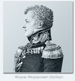 The activities of the famous Russian geodesist and cartographer F.F. Schubert, his ancestor and first director. Fyodor Fyodorovich Schubert (1789-1865) was the eldest of the children and the only son of the outstanding astronomer Academician Fyodor Ivanovich Schubert (1758-1825). Until the age of eleven, he was raised at home, with special attention paid to mathematics and comprehension of languages. During this period F.F. Schubert read a lot of books from his home library, as well as from the library of the Academy of Sciences, which was in charge of his father. In 1800 F.F. Schubert was assigned to the Peter and Paul School, which was then renamed into a school, without finishing which, in June 1803, at the age of only 14, at the request of his father, he was transferred to the General Staff as a column leader.
Quartermaster General P.K. Sukhtelen, a close acquaintance of Fyodor Fedorovich's father, instilled in the young man, who dreamed of naval service, a great love for topographic and geodesic business. In 1804 F.F. Schubert was sent on two astronomical missions, for the successful execution of the first of them he was promoted to second lieutenant. In the spring of 1805 he took part in a scientific expedition to Siberia under the leadership of his father, and in the summer of 1806 he was again busy with astronomical work in Narva and Revel. From October 1806 to February 1819 F.F. Schubert was in the active army, taking part in hostilities against the French, Swedes and Turks. During the battle of Preussisch-Eylau in 1807, he was seriously wounded in the chest and left arm and almost died in the attack of Ruschuk. In 1819 F.F. Schubert was appointed head of the 3rd department of the Military Topographic Depot of the General Staff, and in 1820 he became the head of triangulation and topographic survey of the Petersburg province and in the same year received the rank of Major General.
In 1822 F.F. Schubert develops a draft regulation on the Corps of Military Surveyors and soon becomes the first director of the newly established Corps. After 3 years, he was appointed manager, and from 1832 - director (until 1843) of the Military Topographic Depot of the General Staff and the Council of the General Staff Academy. In addition to the posts of F.F. Schubert from 1827 to 1837 was also the head of the Hydrographic Depot of the Main Naval Staff of His Imperial Majesty. Fedor Fedorovich successfully combined the management of these institutions with a number of other equally responsible duties. He directs extensive trigonometric and topographic work in a number of provinces, organizes the publication of the "Notes of the Military Topographic Depot" and "Notes of the Hydrographic Depot"; compiles and publishes the "Guide for calculating trigonometric surveying and the work of the Military Topographic Depot", which has served as the main guide for topographers for several decades. June 20, 1827 F.F. Schubert was elected an honorary member of the St. Petersburg Academy of Sciences, and in 1831 he was promoted to lieutenant general for excellence in service.
The cartographic works of Fedor Fedorovich are of considerable importance, especially the ten-verst special map of the Western part of Russia, published by him on 60 sheets, known as "Schubert's Maps", as well as his works devoted to the study of the type and size of the Earth. In 1845 F.F. Schubert became a general of infantry, and the following year he was made director of the Military Scientific Committee of the General Staff, which he directed until it was abolished in 1859. With such an abundance of responsible positions F.F. Schubert not only coped well with the responsibilities assigned to him, but also brought a lot of new things into the business of each institution in which he happened to work, therefore his contribution to the development of the national military topographic service was very important, and his authority in the scientific world is very enormous.
Fyodor Fedorovich devoted his free time from public service to numismatics (in 1857 he published a detailed work on this issue). He was fluent in four languages, perfectly versed in music and painting, was a multifaceted, hardworking and cultured person.
The creation of a topographic map of the Moscow province, which was engraved at the Military Topographic Depot in 1860, is also associated with the name of General Schubert. As already indicated above, since 1816 in Russia, large-scale work began on the laying of triangulation and the production of topographic surveys based on a rigorous scientific basis. In 1820 he began his extensive triangulation work and F.F. Schubert. In the period from 1833 to 1839, under his leadership, the triangulation of the Moscow province was carried out, which was fully completed only by 1841. The big flaw in the triangulation work of F.F. Schubert was that he did not pursue the goal of obtaining such a high accuracy, which was inherent in the triangulation of K.I. Tenner and V. Ya. Struve, who were in charge of similar work in Russia at that time. F.F. Schubert attached a purely utilitarian meaning to these works - to provide support only for current topographic surveys, since, being the director of the Military Topographic Depot, he tried to get maps for the largest possible territory of the country. In addition, in his triangulations F.F. Schubert did not pay proper attention to finding the heights of points, which was acutely felt when bringing the lengths of the measured bases to the sea surface. However, these shortcomings of General Schubert's triangulation work were more than compensated for by the high quality of instrumental topographic surveys carried out under his supervision.
The rules for filming have undergone all sorts of variations over time. The general provisions, true for most cases, were as follows. Trigonometric points were intended as the basis for breaking down a geometric network. Only the main objects of the terrain were filmed instrumentally: large roads, rivers, and provincial borders. For this purpose, the serif method was widely used; in forest spaces it was allowed to use compass. The main content of the map was depicted with the help of an eye. In the course of the survey, the relief was transmitted by horizontals indicating the angular value of the slopes of the terrain, and only the contours of the peaks and thalweg were instrumentally applied. The relief was drawn in the office setting with strokes in the Lehmann system.
Topographic instrumental surveys in the Moscow province under the direction of F.F. Schubert were produced in the years 1838-1839. At this time, only the space in the districts of Moscow was filmed. Filming was carried out on a scale of 200 fathoms per inch. The requirements that Fedor Fedorovich made to the performers of field work were very high. Suffice it to say that F.F. Schubert strictly forbade the use of the compass, since it could not give the accuracy that could be achieved by photographing forest roads with the help of alidada. Subsequently, based on the materials of these surveys, in 1848 a topographic map of the environs of Moscow on a scale of 1 verst per inch was published on 6 sheets. After quite a long time, the shooting of the Moscow province was continued. In the years 1852-1853, they were produced under the direction of Major Generals Fitinghof and Rennenkampf and were carried out on a scale of 500 fathoms per inch.
Topographic surveys in the Moscow province were carried out by the forces of the Corps of Military Topographers, but we can hardly now accurately establish the direct performers of the field work, since their names are not on the map of 1860. But on each of the 40 sheets, we can read below the names of the engravers of the Military Topographic Depot, who prepared this map for publication. The fragment of this card, presented to your attention, includes four incomplete sheets, each of which was worked by 6-7 people. It is interesting that among the latter there were two free engravers invited from abroad: Yegor Eglov and Heinrich Bornmiller. These artists taught our engravers the best European methods of engraving and themselves took a direct part in the work "for which, in 1864, the Sovereign Emperor Mostly Deigned to them to wear silver medals on the ribbon of the Order of St. Stanislav, with the inscription" for diligence "".
The original topographic map of the Moscow province of 1860 is a print from an engraving on copper on 40 sheets + a composite sheet, executed in one color. The borders of the province and counties are raised by hand with red watercolor paint. The map is drawn in a trapezoidal pseudocylindrical multifaceted projection of Müfling on a scale of 1: 84,000 or, translated into the Russian system of measures, 2 versts per inch. When compiling the map, materials from topographic surveys made in 1852-1853 were used, but it should be noted that the surveys of 1838-1839 were also used as the basis for creating this map for those sheets that cover the territory of Moscow and its environs. The content of the map is thorough. Of particular interest is the high skill of the engravers, thanks to which all elements of the map are perfectly readable. The relief is perfectly engraved, especially the ravine network: the smallest spurs are drawn, which can simply be missed on current topographic maps of a similar scale. A considerable number of various objects are signed on the map, which makes it possible to use it as a valuable source of data on toponymy, since many hydronyms are now partly lost - they cannot be found on any large-scale topographic map. Even in our time, almost 140 years later, with the help of this document one can quite confidently navigate the countryside. It is not surprising that in Soviet times the presented map was classified as secret.
Hello again! At the beginning of the year, my friends and I visited several abandoned and semi-abandoned villages in the Moscow region. In this regard, I present a new photo report. Here you will be told about the most memorable moments, abandoned houses, curious finds, rural household items and other interesting things.
By the way, I don't write very often from places like this. A similar blog (just part 1) was last fall, you can watch it. Before that, there were a couple of blogs in 2009 and 2010, but now I won't bother looking for it, it's better to go straight to the new part. So, today's reportage is dedicated to a couple of villages and village houses in the Moscow region. All of them are in different ways removed from the capital, but they have one thing in common - either the village is being actively demolished for construction, a couple of living houses remain. Or in the working village there are deaf abandoned houses, which no one has come to for a hundred years, the windows are partially broken, and the fence is missing. This is far from being the case everywhere, but since the capital is growing rapidly, many villages, falling within the boundaries of Moscow, are gradually degrading. Also, the villages near the highways are not lucky, as well as, on the contrary, the villages that are very far from the residential agglomerations. For the most part, such houses are empty, homeless residents often live, and nothing interesting is found. But sometimes quite interesting locations come across. You even wonder how so many old and rather rare things, interior items, old dishes and much more survived. So, I put the photos in a mix to make it proportionally interesting, otherwise some places are quite empty, and some, on the contrary. Go.
1. A typical house built before the revolution. No one lives inside, the door is wide open, the windows are broken. We arrived here in the cold winter. Not the most interesting, but still.
2. We move for several tens of kilometers. We get into the house is more interesting. Shall we sit down for some tea? In the corner we find an old chest, at the table there are Viennese chairs. We raise the seats, we find a pre-revolutionary label, a trifle, but nice) There are many hours scattered on the table. By the way, there will be a lot of hours in the report too.
3. Another house is next. On the terrace we find a portrait of the great poet, which has clearly fallen under the scythe.
4. In one of the houses we find an old piano. The same company, by the way, as the piano thrown by some freaks out the window of an abandoned school (see the blog at the end). This, thank God, is still alive, but the keys are already seizing. At the top of the piano we find a Soviet set of dominoes.
5. Another stopped clock. Ordinary plastic, Soviet.
6. Sometimes houses come across completely destroyed, for example, the roof collapsed after a fire. The sofa looks a little crazy.
7. And this is the house with Pushkin on the terrace. The ceilings are rotten, the floor is falling through. For example, here, the closet fell down.
8. An experienced birdhouse next to one abandoned vegetable garden at the house.
9. In the attic you can often find various interesting things. In this house, for example, these are ancient objects of peasant life (spinning wheels, rakes, pitchforks, wooden shovel, sieve, etc.), notebooks of the 20s and 30s, textbooks of the same time, newspapers, Christmas tree decorations, porcelain dishes, etc. This frame still shows the radio in a very poor condition from the 1940s.
10. Typical cuisine in such houses. An old stove, a water heater, a nice but dusty mirror, and all sorts of junk.
11. Baby dolls always look especially creepy.
12. Another curious room. Here we find the pre-revolutionary Singer sewing machine, or rather a table from her and her. The condition is very unimportant. Time and dampness do their job. There are a lot of old and half-rotten clothes in the closets.
13. Show the base of the camp. Rusty letters "ZINGER" on the back.
14. Every country house should have a red corner.
15. On the way past residential buildings, local inhabitants often come across)
16. Rusty bikes were found on the terrace.
17. And here in the room on the floor is a curious clock.
18. House in the village a short distance from the rest. Strange, by the way. In one room the ceiling collapsed, in the second one is barely breathing, there is practically no fence, the windows are knocked out, and the light in one of the rooms was still working! traces of devastation are visible inside.
19. This leaflet hooked me very strongly. Learning to write in the 1920s. "Get up, branded by a curse, the whole world of hungry and slaves!"
20. In the kitchen in an abandoned house. Letters come across underfoot, an old radio set on the wall.
21. All clocks show different times.
22. Nice wooden shelf.
23. Cover photo. The rug looks especially sad. Russia-three, where are you rushing? And really, where ...
24. Soviet pinball. Curious thing, never seen before. Although I saw a lot of the Chinese 90s. The state is awful.
25. One hut, almost completely blown apart.
26. In the house from shot 18. Buffet in the kitchen. Surprisingly perfect save! As if no one has lived for two or three years, but no one has climbed or beaten. Although the dishes are late Soviet and not uncommon, so it is not surprising.
27. Notebooks of the 20s, 30s, this time closer. Decorated with portraits of Lunacharsky, Lenin, faces of peasants and pioneers. And of course, "Workers of all countries, unite!"
28. In the house with 1 photo right on the doorstep we find such a wonderful chest
29. A little bit of May nature from the village plots =)
30. And again we find the pinball. Condition is not much better.
31. One kitchen. It is strange that everything is just so thrown. Despite the seeming order, the dishes are under a layer of dust, the ceiling behind has already collapsed.
32. Nice pre-revolutionary buffet in the piano room.
33. The quality of the frame did not come out very well, but I will post it anyway. Interesting content. Geometry notebook from 1929.
35. In this frame I would like to finish today's photo report.
Such abandoned houses make a very sad and painful impression. It seems that part of our culture is leaving. The metropolitan way of life is changing the old established way of life. Is it good or bad? How much progress is needed, and what are we striving for? But these are rather philosophical questions, and everyone will have their own answer. Enough reasoning for today. Until next reports!


