Viking map. Navigation of the ancient Scandinavians. What is a "sun stone"? Vikings in video games
The medieval Viking Age refers to the period of the 8th-11th centuries, when the European seas were plied by bold robbers from Scandinavia. Their raids struck terror into the civilized inhabitants of the Old World. The Vikings were not only robbers, but also merchants, as well as pioneers. By religion they were pagans.
The advent of the Vikings
In the VIII century, the inhabitants of the territory of modern Norway, Sweden and Denmark began to build the fastest ships at that time and go on long journeys on them. The harsh nature of their native lands pushed them to these adventures. Agriculture in Scandinavia was underdeveloped due to the cold climate. A modest harvest did not allow local residents to feed their families enough. Thanks to the robberies, the Vikings became noticeably richer, which gave them the opportunity not only to buy food, but also to trade with their neighbors.
The first attack by sailors on neighboring countries occurred in 789. Then the robbers attacked Dorset in the south-west of England, killed thethen and robbed the city. Thus began the Viking Age. Another important reason for the emergence of mass piracy was the decomposition of the former system based on community and clan. The nobility, having strengthened its influence, began to create the first prototypes of states. For such Jarls, robberies became a source of wealth and influence among compatriots.
Skilful sailors
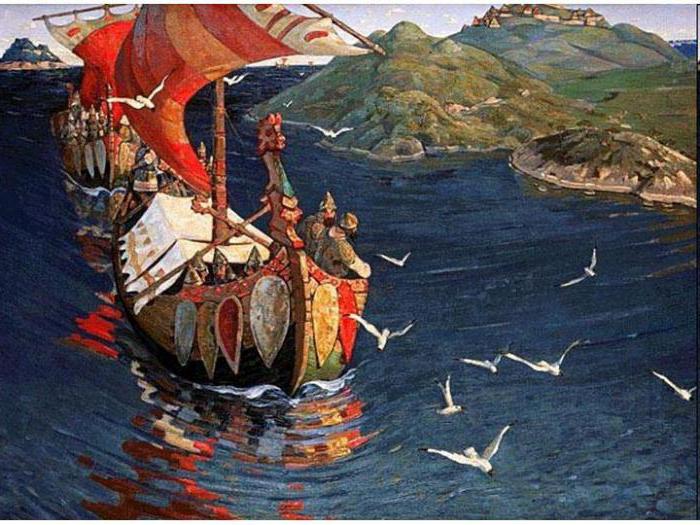
The key reason for the conquests and geographical discoveries of the Vikings was their ships, which were much better than any other European ones. The warships of the Scandinavians were called drakkars. Sailors often used them as their own home. Such vessels were mobile. They could be relatively easily dragged ashore. At first, the ships were oared, later they acquired sails.
Drakkars were distinguished by their elegant shape, speed, reliability and lightness. They were designed specifically for shallow rivers. Entering them, the Vikings could go deep into the devastated country. Such voyages came as a complete surprise to Europeans. As a rule, drakkars were built from ash wood. They are an important symbol left behind by early medieval history. The Viking Age is not only a period of conquest, but also a period of development of trade. For this purpose, the Scandinavians used special merchant ships - knorrs. They were wider and deeper than the Drakkars. Much more goods could be loaded on such ships.
The Viking Age in Northern Europe was marked by the development of navigation. The Scandinavians did not have any special devices (for example, a compass), but they perfectly managed the prompts of nature. These sailors thoroughly knew the habits of birds and took them with them on a voyage to determine if there was land nearby (if there was none, the birds returned to the ship). The researchers also focused on the sun, stars and moon.

Raids on Britain
The first Scandinavian raids into England were fleeting. They plundered defenseless monasteries and promptly returned to the sea. However, gradually the Vikings began to claim the lands of the Anglo-Saxons. There was no single kingdom in Britain at that time. The island was divided among several rulers. In 865, the legendary Ragnar Lodbrok went to Northumbria, but his ships ran aground and crashed. Uninvited guests were surrounded and captured. King Ella II of Northumbria executed Ragnar by ordering him to be thrown into a pit full of poisonous snakes.
The death of Lodbrok did not go unpunished. Two years later, the Great Pagan Army landed on the coast of England. This army was led by numerous sons of Ragnar. The Vikings conquered East Anglia, Northumbria and Mercia. The rulers of these kingdoms were executed. The last stronghold of the Anglo-Saxons was South Wessex. His king Alfred the Great, realizing that his forces were not enough to fight the interventionists, concluded a peace treaty with them, and then, in 886, completely recognized their possessions in Britain.
Conquest of England
It took Alfred and his son Edward the Elder four decades to clear their homeland of foreigners. Mercia and East Anglia were freed by 924. In remote northern Northumbria, Viking rule continued for another thirty years.
After some lull, the Scandinavians again began to appear frequently off the British coast. The next wave of raids began in 980, and in 1013 Sven Forkbeard completely captured the country and became its king. His son Canute the Great ruled three monarchies at once for three decades: England, Denmark and Norway. After his death, the former dynasty from Wessex regained power, and foreigners left Britain.
In the 11th century, the Scandinavians made several more attempts to conquer the island, but they all failed. The Viking Age, in short, left a noticeable imprint on the culture and government of Anglo-Saxon Britain. On the territory that the Danes owned for some time, the Danelag was established - a system of law adopted from the Scandinavians. This region was isolated from other English provinces throughout the Middle Ages.

Normans and Franks
The Viking Age is the period of the Norman attacks. Under this name, the Scandinavians were remembered by their Catholic contemporaries. If the Vikings sailed to the west mainly in order to rob England, then in the south the Frankish Empire was the goal of their campaigns. It was created in 800 by Charlemagne. As long as under him and under his son Louis the Pious a single strong state was preserved, the country was reliably protected from the pagans.
However, when the empire broke up into three kingdoms, and those in turn began to suffer from the costs of the feudal system, dizzying opportunities opened up for the Vikings. Some Scandinavians robbed the coast every year, while others were hired into the service of Catholic rulers in order to protect Christians for a generous salary. During one of their raids, the Vikings even captured Paris.
In 911, the Frankish king Charles the Simple gave the Vikings this region became known as Normandy. Its rulers were baptized. This tactic proved to be effective. More and more Vikings gradually switched to a settled way of life. But some daredevils continued their campaigns. So, in 1130, the Normans conquered southern Italy and created the Kingdom of Sicily.
Scandinavian discovery of America
Moving further west, the Vikings discovered Ireland. They often raided this island and left a significant imprint on the local Celtic culture. For more than two centuries, the Scandinavians owned Dublin. Around 860, the Vikings discovered Iceland ("Ice Country"). It was they who became the first inhabitants of this deserted island. Iceland proved to be a popular place for colonization. The inhabitants of Norway, who fled the country due to frequent civil wars, sought to go there.
In the year 900, a Viking ship, accidentally lost its way, stumbled upon Greenland. The first colonies appeared there at the end of the 10th century. This discovery inspired other Vikings to continue their search for a way to the west. They rightly hoped that there were new lands far beyond the sea. The navigator around the year 1000 reached the shores of North America and landed on the Labrador Peninsula. He called this region Vinland. Thus, the Viking Age was marked by the discovery of America five centuries before the expedition of Christopher Columbus.
Rumors about this country were fragmentary and did not leave Scandinavia. In Europe, they never learned about the western mainland. Viking settlements in Vinland lasted for several decades. Three attempts were made to colonize this land, but they all failed. Indians attacked strangers. Keeping in touch with the colonies was extremely difficult because of the vast distances. Eventually the Scandinavians left America. Much later, archaeologists found traces of their settlement in Canadian Newfoundland.

Vikings and Russia
In the second half of the 8th century, Viking troops began to attack the lands inhabited by numerous Finno-Ugric peoples. This is evidenced by the finds of archaeologists discovered in the Russian Staraya Ladoga. If in Europe the Vikings were called Normans, then the Slavs called them Varangians. The Scandinavians controlled several trading ports along the Baltic Sea in Prussia. Here began a profitable amber route, along which amber was transported to the Mediterranean.
How did the Viking Age affect Russia? In short, thanks to the newcomers from Scandinavia, East Slavic statehood was born. According to the official version, the inhabitants of Novgorod, who often had contact with the Vikings, turned to them for help during an internal civil strife. So the Varangian Rurik was invited to reign. A dynasty came from him, which in the near future united Russia and began to rule in Kyiv.
Life of Scandinavian people
At home, the Vikings lived in large peasant dwellings. Under the roof of one such building fit a family that included three generations at once. Children, parents, grandparents lived together. This custom was an echo. Houses were built from wood and clay. The roofs were turf. In the central large room there was a common hearth, behind which they not only ate, but also slept.
Even when the Viking Age came, their cities in Scandinavia remained very small, inferior in size even to the settlements of the Slavs. People concentrated mainly around craft and trade centers. Cities were built in the depths of the fjords. This was done in order to get a convenient harbor and, in the event of an attack by an enemy fleet, to know in advance about its approach.
Scandinavian peasants dressed in woolen shirts and short baggy trousers. The costume of the Viking Age was quite ascetic due to the scarcity of raw materials in Scandinavia. Wealthy members of the upper classes could wear colored clothes that distinguished them from the crowd, showing wealth and position. The women's costume of the Viking Age necessarily included accessories - metal jewelry, a brooch, pendants and belt buckles. If the girl was married, she put her hair in a bun, unmarried people picked up her hair with a ribbon.

Armor and weapons of the Vikings
In modern popular culture, the image of a Viking with a horned helmet on his head is common. In fact, such headdresses were rare and were no longer used for combat, but for rituals. The clothing of the Viking Age included the obligatory light armor for all men.
Weapons were much more diverse. The northerners often used a spear about one and a half meters long, with which they could chop and stab the enemy. But the most common was the sword. These weapons were very light compared to other types that appeared in the subsequent Middle Ages. The Viking Age sword was not necessarily made in Scandinavia itself. Warriors often acquired Frankish weapons, as they were of the best quality. The Vikings also had long knives - the Saxons.
The inhabitants of Scandinavia made bows from ash or yew. Braided hair was often used as a bowstring. Axes were a common melee weapon. The Vikings preferred a wide, symmetrically divergent blade.

The last Normans
In the first half of the 11th century, the Viking Age came to an end. It was due to several factors. Firstly, in Scandinavia the former tribal system finally decomposed. It was replaced by classical medieval feudalism with overlords and vassals. Remained in the past and half Scandinavians settled in their homeland.
The end of the Viking Age also came because of the spread of Christianity among the northerners. The new faith, unlike the pagan one, opposed bloody campaigns in a foreign land. Many sacrificial rituals were gradually forgotten, etc. The first to be baptized were the nobility, which, with the help of the new faith, legitimized in the eyes of the rest of the civilized European community. Following the rulers and the aristocracy, ordinary residents did the same.
In the changed conditions, the Vikings, who wanted to connect their lives with military affairs, went into mercenaries and served with foreign sovereigns. For example, the Byzantine emperors had their own Varangian guards. The inhabitants of the north were valued for their physical strength, unpretentiousness in everyday life and many combat skills. The last Viking in power in the classical sense of the word was King Harald III of Norway the Severe. He went to England and tried to conquer it, but died at the Battle of Stamford Bridge in 1066. Then came the end of the Viking Age. William the Conqueror from Normandy (himself also a descendant of the Scandinavian sailors) conquered England in the same year.
Robbery and military campaigns of the Vikings in England and France, as well as expeditions to the Mediterranean Sea, during one of which, for example, 62 ships led by the legendary Hastein in 895.
reached Byzantium, far from fully characterize their achievements as navigators. The navigational art of the Vikings and the seaworthiness of their ships are evidenced by the voyages that ended with the settlement of Iceland and Greenland and the discovery of America.The first Norwegians appeared in the Hebrides around 620. Almost 200 years later, in 800, they settled on the Faroe ("Sheep") Islands, and in 802 on Orkney and Shetland. In 820, they created a state in Ireland, which was located in the area of \u200b\u200bmodern Dublin, and lasted until 1170.
Information about Iceland was brought to the Vikings by the Swede Gardar Svafarsson, who in 861 transported his wife's inheritance from the Hebrides. During the passage, his ship was carried by a storm to the northern coast of Iceland, where he spent the winter with the crew. When in 872 Harald the Fair-haired created a great kingdom in Norway by force, Iceland became a target for those Norwegians who did not want to obey the king. It is believed that between 20,000 and 30,000 Norwegians moved to Iceland before 930. With them they carried household items, seeds and pets. Fishing, farming and cattle breeding were the main occupations of the Vikings in Iceland.
The Icelandic sagas that have come down to us, passed down from generation to generation and recorded only in the 13th and 14th centuries, are the most important sources of information about the Vikings. The sagas tell us about the Viking settlements in Greenland and the discovery of America, which they called Vinland.
So, in the saga of Eirik Raud (Redhead), recorded around 1200 by Hauk Erlendsson, it is said that in 983 Eirik, expelled from Iceland for three years for murder, sailed in search of the country that Gunbjorn saw when he sailed in " Western Sea". Eirik the Red reached Greenland and settled there with a group of Icelanders. The settlement was named Brattalid. Bard Herjulfsson also lived there. In 986 his son Bjarni sailed from Iceland with the intention of reaching Greenland. During the voyage, he stumbled three times on unfamiliar land, until he finally found his father, who lived on the southern tip of Greenland. Upon his return to Norway, Bjarni spoke about his voyage at the court of King Eirik. The son of Eirik the Red - Leif Eriksson - bought a ship from Bjarni and sailed on it with 35 people to Brattalid. After careful preparation, they first repeated Bjarni's journey to the Labrador Peninsula. When they reached it, they turned south and followed the coast. According to the Greenland saga, recorded in 1387 by Jon Todarsson of Flateybuk, they reached the area they called Vinland - the Country of Grapes. Wild grapes, maize grew rapidly there, salmon was found in the rivers. The southern boundary of salmon distribution approximately corresponded to 41° latitude. The northern border of wild grapes was near the 42nd parallel. Thus, Leif and his team in about 1000 reached the places where Boston is currently located (Fig. 1).
Leif's brother, Torvald, after his story, on the same ship with 30 people, also reached Vinland, where he lived for two years. During one of the skirmishes with the locals, Torvald was mortally wounded, and the Vikings left the settlement. Later, Leif's second brother, Thorstein, wanted to reach Vinland on the same ship, but could not find this land.
On the coast of Greenland in a number of places there were settlements of Icelanders, up to 300 households in total. Great difficulties for living there arose due to the lack of forests. The forest grew on Labrador, which is closer to Greenland than Iceland, but sailing to the Labrador Peninsula was dangerous due to the harsh climate. Therefore, the Vikings living in Greenland had to carry everything they needed from Europe on ships that looked like ships from Skullelev. This is confirmed by the excavations of graves in Greenland, in which the remains of ships were also found. In the XIV century. Viking settlements in Greenland ceased to exist.
Notes:
In the XI century. In addition to England, the Normans captured Sicily and Southern Italy, establishing here at the beginning of the 12th century. "Kingdom of the Two Sicilies". The author mentions exclusively the predatory and military campaigns of the Danes and Norwegians and does not say anything about the Swedes, whose expansion was directed mainly to Eastern Europe, including Russia.
The decisive battle between Harald and his opponents at Hafrsfjord took place shortly before 900, and therefore there was no direct connection between the migrations to Iceland and the political events in Norway.
Currently, there are about forty hypotheses about the location of Vinland. The hypothesis of the Norwegian ethnologist X. Ingstad, who in 1964 discovered the ruins of a settlement in Newfoundland, which he identified as Vinland of the Normans, is equally undeniable. A number of scholars believe that this settlement belongs to the Eskimo Dorset culture. In addition, in the sagas, the climate of Vinland is assessed as mild, which does not correspond to the harsh subarctic climate of Newfoundland.
▫ Frame 1 `Where is the button, where is the button... Would you like to know where he is...` Frame 2 `Listen, Ryzhikov, why do you always need it most of all? Do you want to become famous?` Frame 3 `Yes, they don’t have buttons, you understand? No!` Frame 4 `Makar, don't be so bold! Don't hold on! Here the most complicated, serious questions in science are solved!` Frame5 `What else is there?! Take it easy, calm down! Let's continue the lesson. And I will investigate the phenomenon of Syroezhkin after class.` Frame 6 `We have already gone to the second round. It's not hockey, it's a marathon. You slipped me a good player!` Frame 7 `We will figure it out without you. We'll call a dozen bespectacled assistant professors, they'll take your guy apart and `Frame 8` Professor, this is impossible. It contradicts any theory.` Shot 9 `Well, Sausage, hold on!` Shot 10 `Well, are you sure, electronic idiots?` Shot 11 `Nothing. Step towards glory.` Frame 12 `Trust my experience, everything is possible in school.`
▫ to South America of course http://vk.com/topic-47976727_39020830
▫ Among swollen candles and evening prayers, Among war trophies and peaceful bonfires, Bookish children lived, who did not know battles, Exhausted from their petty disasters. Children are always annoyed by their age and way of life, And we fought to the bruises, to mortal insults, But our mothers patched our clothes on time, We swallowed books, drunk from the lines. Hair stuck to our sweaty foreheads, And sucked sweetly from the phrases in the pit of the stomach, And the smell of struggle circled our heads From the yellowed pages flying down on us. And we tried to comprehend, who did not know wars, Taking a howl for a warlike cry, The secret of the word order, the appointment of borders, The meaning of the attack and the clang of war chariots. And in the boiling cauldrons of former wars and troubles, So much food for our small brains, We are the roles of traitors, cowards, Judas, In our children's games we appointed enemies. And the traces of the villain were not allowed to cool, And they promised to love the most beautiful ladies, And reassuring friends, and loving neighbors, We introduced ourselves to the roles of heroes. Only in dreams you can’t run away for good, A short age of fun, so much pain around, Try to unclench the palms of the dead And take weapons from hard-wearing hands. Try it, having taken possession of a still warm sword, And putting on armor, what's the price, what's the price, Figure out who you are? - a coward or a chosen one of fate, And taste the real struggle. And when a wounded friend collapses nearby, And over the first loss you howl in grief, And when you suddenly remain without skin, Because they killed him, not you. You will understand that you have recognized, distinguished, found, On the grin you took this grin of death, Lies and evil, look how their faces are rude, And always behind crows and coffins. If you didn’t eat a piece of meat from a knife, If you folded your hands, watched from above, But you didn’t enter into a fight with a scoundrel, an executioner, It means that in life you had nothing to do with it, nothing to do with it. If, cutting through the path with your father's sword, You wound salty tears on your mustache, If in a hot battle you experienced what was worth, It means that you read the necessary books as a child. (c) V.S. Vysotsky
▫ Pajama party 5+
▫ Light Illuminated my sick soul. No, I will not disturb your peace with passion. Brad, Midnight delirium torments my heart again. Oh Esmeralda, I dared to desire you. My heavy cross - ugliness is an eternal seal, I am ready to accept compassion for love. No, outcast hunchback with a curse on his forehead - I will never be happy on earth. And after death I will not find peace, I will sell my soul to the devil for a night with you. Paradise Your embrace promises paradise. Give Me hope, oh my curse. Know that blind power is sweet to me of sinful thoughts, A madman before - I did not know what passion meant. A dissolute girl, like a demon, is possessed; The impudent gypsy ruined my life. It's a pity, I'm dressed in a cassock with a mockery of fate, Forever doomed to the torments of hell. And after death I will not find peace, I will sell my soul to the devil for a night with you. Sleep, my bright dream of happiness, Esmeralda. Groan, my sinful passion groan, Esmeralda. It broke from the lips and rolled down like a stone, The heart of the blonde Fleur-de-lis broke. Holy Virgin, you cannot help me. Forbidden love is not given to me to overcome. Stop, Do not leave me a crazy dream, Beauty turns a man into a slave. And after death I will not find peace, I will sell my soul to the devil for a night with you. And day and night, only she is in front of me. And I do not pray to the Madonna, but to her alone. Stop, Do not leave me a crazy dream, Beauty turns a man into a slave. And after death I will not find peace, I will sell my soul to the devil for a night with you.
Test tasks.
1. In ancient times in Russia, the inhabitants of the Scandinavian Peninsula were called Vali
a) Vikings
b) Normans
c) Varangians
d) Scythians
2. How many centuries before Columbus did the Vikings discover America?
c) for 10
3. What was the relationship between Eirik and Leif?
a) were brothers
b) Eirik was the son of Leif
c) Eirik was the father of Leif
d) Eirik was Leif's grandfather
4. In order to get from Iceland to America via Greenland, the Vikings had to sail
a) first to the east and then to the north
b) first to the west and then to the south
c) first east, then south
d) first to the west, then to the north
5. The discovery of America by the Vikings is mentioned in
a) The Saga of the Icelanders
b) "Saga of the Greenlanders"
c) "The Saga of the Americans"
d) Indian Saga
6. Fill in the gaps in the text.
The Vikings first settled the entire coast of the Scandinavian Peninsula, then occupied the island of Iceland. Later, they discovered and began to develop a huge island, which they called Greenland. A few years later, the son of Eirik the Red, whose name was Leif, managed to find a vast land, which the Vikings began to call Happy Vinland.
Thematic workshop.
Here are three passages from the Greenlanders' Saga. Put them in the correct order and answer the questions.
1. Eirik found the country he was looking for, and approached the land near the glacier, which he called the Middle. He called the country he discovered Greenland (Green Country), because he believed that people would rather want to go to the country if it had a good name.
2. Once a man disappeared, and then he came and brought a vine. And Leif named the country according to what was good in it: it was called Grapeland or Vinland. It was around the year 1000. And after the return of Leiva, everyone began to call Leif the Happy.
3. There lived a man named Torvald. He was the son of Aswald, the son of Thorir the Bull. Thorvald and his son Eirik the Red left the Yard because of the murders they committed in the feud and left for Iceland.
1. A cape in southern Africa has long been called the Cape of Storms. The Portuguese king João II renamed it the Cape of Good Hope. What do you think brings Leif the Happy closer to King Juan II?
I think that both were at the cape with good hope.
2. Who was Eirik the Red Bull Thorir?
Bull Thorir was the great-great-grandfather of Eirik the Red.
Cartographic workshop.
Trace the route of the Vikings (Normans) on the map and name the geographical objects through which it passed.
1. Norway.
2. Norwegian Sea.
3. Iceland.
4. Atlantic Ocean.
5. Greenland.
6. Baffin Island.
7. Labladore Peninsula.
8. Newfoundland Island.
Homeland of the Normans
INdiscovery, often secondary, after the ancient Irish, and in the development of the North Atlantic in the VIII-X centuries. the largest role was played by the Normans - "northern people". So the medieval Western Europeans called the Danes (Danes), Norwegians and Swedes (Swedes). Ethnographers and linguists unite them under the general term "Scandinavians". Not later than the 3rd c. n. e. in Scandinavia, runic writing appeared, which arose on the basis of the alphabet of one of the peoples of the Mediterranean. In the 8th century the Normans were in the process of transition from the pre-class system to the class system. The Danes then occupied the low-lying peninsula of Jutland and the chain of small North Frisian Islands bordering it in the west, the low-lying Danish archipelago, located south of the Kattegat Strait, and the hilly plain of Skopje, the southeastern ledge of Scandinavia. To the north of Skåne lived the Öts (Göts) and Svions (Svei), who inhabited the region of the great Scandinavian lakes Vänern, Vättern and Mälaren, as well as the Baltic islands of Gotland and Öland.
The Norwegians occupied the southwestern part of Scandinavia, adjacent to the Bohus Bay and the Skagerrak Strait, and the shores of the western fjords up to 64 ° N. sh. with adjacent islands. The largest of the fjords: at 59 ° N. sh. - wide Bokna Fjord, at 60° - Hardanger Fjord, at 61° N. sh. - the greatest Sognefjord, at 63 ° 30 "is a long and wide Tropheims Fjord, on the southern coast of which the city of Nidaros (now Trondheim) was founded at the end of the 10th century - the ancient capital of united Norway. The coastline between 65 and 67 ° N. sh., mastered in the 9th century, the Norwegians called the Helgeland region.
Ways and raids of the Normans
ABOUTThe main occupations of the ancient Normans were cattle breeding and sea crafts. In search of fish and sea animals, they made long voyages in the northern seas. Agriculture in Scandinavia and on the plains of Denmark did not provide the population with bread even in good years. And the Normans set off across the sea in order to exchange furs, fish, leather, honey and fat for bread and other agricultural products in the agricultural countries of Europe. They combined simple trade with the slave trade, since in some European regions slaves were then the most valuable commodity.
Viking Drakar under sail.Paolo Novaresio, The Explorers, White Star, Italy, 2002 |
In the Scandinavian countries, during the decomposition of the tribal system, a tribal nobility stood out. After the death of the head of the family, which was part of this elite, the property, according to custom, became the property of the eldest son. To provide for the younger, disadvantaged sons, the father, as a rule, "let them go around the world", only not with a bag, but with a boat. The sons of noble Normans recruited military squads from enslaved, free people - bonds, who themselves were often engaged in trade, and led predatory sea expeditions to the "bread" countries of Europe. The leaders of these squads - kings ("sea kings") - sometimes acted as merchants, but more often as pirates: they seized ships, robbed coastal and riverine villages and cities. According to the sagas, the Normans used various types of military (pirate) ships, the main of them by the beginning of the 9th century. there was a kner - a single-masted shallow-draft oak sailboat with 16 pairs of oars, about 24 m long and about 5.5 m wide, which has proven itself both in sea and river trips. During the voyages, the Normans were guided by the sun and stars, in particular by the Polar, which bore the name Leidar.
The Scandinavians themselves called the participants of the pirate expeditions the Vikings. The origin and original meaning of this term is not entirely clear. Now most historians share the opinion of those Swedish scientists who derive the term "Viking" from the verb "Vikya" - to turn, deviate. "Viking" - ... this is a person who sailed away from home, left his homeland, that is ... a sea warrior, a pirate who went on a campaign for prey. (A. Gurevich).
From their shores, the Normans sailed and raided in all directions. Moving east, they (mainly the Swedes) crossed the Baltic Sea, entered the Gulf of Riga and the Gulf of Finland and, using the ancient Russian trade routes, reached the rivers of Eastern Europe, the Black and Caspian Seas, and through them penetrated into Byzantium, the Arab caliphates and Central Asia . From there they delivered silks, spices, wines, jewelry and silver in coins to Europe.
Moving west, the Normans (mostly Norwegians) settled on the islands of the North Atlantic, were the first to cross the ocean, discovered Greenland and visited the northeastern shores of America. Danish and Norwegian Vikings fortified themselves in some of the small British Isles and in the east of Ireland. On about. Great Britain, they partly subjugated the Anglo-Saxons to their power, partly took huge ransoms from them or imposed a heavy tax - “Danish money”. They conquered England twice and retreated temporarily.
Moving south to the shores of France, the Normans conquered the lower reaches of the Seine, the Cotentin Peninsula, which since that time is often called Normandy, and the nearby islands of Jersey and Guernsey - they are now called Norman. Having fortified themselves in coastal Northern France, but having lost their language, the Frenchized Normans, led by Wilhelm Bastard(“Illegitimate”) in 1066 conquered England - for the third time, but now completely.
Moving even further south, plundering the coast of the Bay of Biscay and the Atlantic shores of the Iberian Peninsula, the Normans penetrated the Mediterranean Sea through Gibraltar, fought at sea with the Arabs, ravaged the coastal strip of Southern Europe and reached Sicily and Southern Italy. There they could meet their countrymen - or their Swede neighbors - in the Byzantine service, sent from Constantinople, where they came along the rivers of Eastern Europe "from the Varangians and Greeks." Thus, the Norman waterways in the IX-XI centuries. encircled all of Central, Western and Southern Europe, capturing a fairly wide strip of Eastern Europe.
Normans on the Baltic Sea and the discovery of the Baltic
HThe beginning of the activity of the Normans (mainly Swedes) on the Baltic Sea dates back approximately to the middle of the 7th century. They got acquainted with the northern part of this water area, discovered Aland - a large (6.5 thousand) cluster of hilly islands (Aland Islands) - and were the first to penetrate the Gulf of Bothnia, in the 9th century. on its southeastern shore, a barter point arose - the future city of Turku. Their sea scouts, moving along the northern, strongly indented and rocky shore of Kirialbotn (Gulf of Finland), reached its summit and along the lake-river system Neva (in the runic inscriptions "Nuya") - Ladoga - Svir - Onego reached the expanses of Garda - north- western part of the East European Plain - and, therefore, became the discoverers of the mainland's largest lakes. According to the latest ideas, the Normans appeared on the White Lake and the upper Volga about a century earlier than the Slavs. The contacts of Scandinavia with the Ladoga region were not only trade. Archaeological excavations confirm the fact of Swedish colonization of this territory. The peak of the Swedes' activity falls on the 10th century, at the beginning of the 11th century. it weakens, and by the end of the XI century. stops. The main role in the development of the ancient Baltic-Volga trade route belongs to the kolbyags - Swedish fur traders. Its western terminus was the city of Birka, which arose around 800 on Lake Mälaren. Strongholds were founded along the route for the collection and exchange of goods, including in the middle of the 8th century. Staraya Ladoga, in the lower reaches of the river. Volkhov, near the southern shore of Lake Ladoga.
In the second half of the 7th-8th centuries. the Normans reached the western low-lying coast of the Baltic states, discovered the Moonsund arch. Numerous (more than 500) group of low-lying islands at the entrance to the Gulf of Riga. The sagas retained the Norman names of the largest of them - Eysüsla (Saaremaa) and Dagaipi (Hiiumaa). and for the first time penetrated the Gulf of Riga, deeply protruding into the mainland. They took advantage of the ancient trade route that led up the Western Dvina ("Vina" or "Duna") through the portage to the Dnieper. Since the 9th century, after the formation of the city of Turku, the Swedes preferred to cross the Gulf of Finland and follow the Western Dvina to the south along Estland - the western coast of the Baltic, inhabited by Estonians, and the sloping sandy shores of the Gulf of Riga - Lifland (land of the Livs, "Lib" of Russian chronicles ). They also explored Virland - the southern, mostly low-lying coast of the Gulf of Finland, in sections breaking off to the sea in the form of a ledge - klint (this is a word of Scandinavian origin).
At least from the second half of the 7th c. the Swedes visited the shores of the Baltic and south of the Gulf of Riga up to the Gdansk Bay and captured part of the coastal strip of Lifland, where ancient Latvian tribes lived (Western Latvia). They undoubtedly discovered the Curonian and Vistula lagoons - lagoons about 90 km long, “fenced off” from the sea by narrow sandy spits. This is evidenced by the Norman burials in the region of Liepaja with weapons of a typical Swedish type (about 650); a point at the southwestern peak of the Curonian Lagoon, founded by the Swedes around 850 to carry out trade operations with the Black Sea countries; Norman burials of the 8th century, discovered in Truso, An ancient trading town in the eastern part of the Vistula delta, near Lake Druzno, south of modern Elbląg. near the Vistula Lagoon. According to Scandinavian sources, the Normans "combined" trade with robber attacks on the coast in the 9th-10th centuries. Thanks to their semi-merchant-semi-pirate activities, a coastal strip of the Baltic States about 1600 km long was discovered, from the mouth of the Neva to the Gdansk Bay.
80s 9th century Norwegian Oter- sailor, St. John's wort, merchant and small landowner - told the king of England Alfred the Great, with whom he was then in the service, that his homeland Helgeland is “... the northernmost of all the Norman lands ... To the north, the land stretches for a long distance, but is completely deserted, except for a few places where the settlements of the Finns are scattered [ Saami, often called Lapps and Laplanders], who hunt in the winter and fish in the summer.” Oter told Alfred briefly and truly about the part of Norway that had been mastered by that time. In the literature, this is the first generally correct geographical information about the Scandinavian Peninsula: “... the country of the Normans [Norwegians] is very long and narrow. All pastures and arable land are located along the seashore. In some places [the coastal zone] is completely mountainous, and beyond the strip of cultivated land, wild desert peaks rise everywhere. Finns live in the mountains. The strip of cultivated land reaches its greatest width towards the east [in the southeast] and narrows towards the north. In the eastern [southeastern] part it is 60 miles or more wide, in the middle it is 30 miles or more, and in the north it narrows to 3 miles. Inland, the desert lands stretch so far in places that they can be crossed in only two weeks, but in other places it would take no more than six days. On the other side of the desert lands, Svealand [Sweden] neighbors the country of the Normans, further to the north - Kvenland ... ”- the country of the Kvens, representing the northwestern branch of the Finns-Suomi.
Oter skirted the Scandinavian Peninsula from the southwest and north. To the south, as he informed the king, he sailed from Helgeland to the Danish harbor of Hedeby (Haitabo), which he calls "At-Hetum" or "Hetum", in the lower reaches of the river. Schlei, which flows into the Kiel Bay of the Baltic Sea. His path went through the Skagerrak to the southern harbor of Skiringsal (near the Oslo Fjord), In our time, archaeologists have found undoubted traces of an ancient trading post on the western shore of the Oslo Fjord. and from there he went straight south to Hedeby through the Kattegat and the Great - or Small - Belt: “According to him,” the king, or rather the scribe who was present at the conversation, recorded, “the voyage there [to Skiringsal from Helgeland] will take more than a month, provided that at night you will have to anchor, and during the day you will have to sail with a fair wind. The entire voyage runs along the coast... Norway will be visible from the port side. South of Skiringsal, a huge [Baltic] sea juts out into the land ... many hundreds of miles inland ... From Skiringsal he sailed for another five days and reached ... At-Hetum. This harbor is located between the lands of the Wends [Baltic Slavs], Saxons and Angles and belongs to the Danish king. On the way from Skiringsal, on the port side he had Denmark [the Skåne peninsula], and on the starboard side - the sea ... And during the last two days of sailing to Hethum, on the starboard side was Jutland ... and many islands. The Angles lived in these places before they came to our country [Britain]. From the left side, in these last days of navigation, he saw the islands belonging to Denmark ... "
Answering the king's questions, Oter told him about his other voyage - to Biarmia (more correctly - Bjarmu). A few phrases about her, interspersed in the story of a sea voyage around the Scandinavian Peninsula (see below), caused many years of controversy about what kind of country it is and where it is located. According to Oter, he reached “... the mouth of a large river. He entered the river because he did not dare to continue swimming further, fearing a collision with the inhabitants of the coast, which was densely populated on the other side of the mouth. Biarmia turned out to be a country of skillfully cultivated arable land, the inhabitants of which, however, opposed their [Norwegians] landing on the shore. Oter also said that the Biarmians told him about their own and neighboring lands. "But what is true in their story and what is not, he does not know." And, probably, answering the natural question, how did Oter explain himself to them, the Norwegian from Helgeland, who knew the neighboring Finns (Saami) well, said: “It seemed to him [a reasonable reservation] that the Finns and the inhabitants of Biarmia speak the same language ".
About the features of the river. The wine flowing through Biarmia can be seen from the ancient sagas. The river flows into the sea at one mouth (vinuminni), and on its hilly banks (vinubakka) grows a mixed forest (viiuskogr), high and dense. This stingy characterization, combined with the mention of a large population and cultivated fields, leaves no room for doubt: we are talking about the Western Dvina (Daugava). This conclusion is confirmed by the testimony of Saxo Grammatik about the campaign of the Danes in Biarmia. They crossed all of Central Europe and attacked the Biarmians. Having been defeated, the Danes retreated “to the land of the Kurs [Cursians] and Zembs [Semgals]”, i.e. in the region of Central and Western Latvia, where these ancient Latvian tribes lived. In other words, Biarmia occupied the territory of Estonia, Northern and Eastern Latvia.
At the same time as Oter, Alfred apparently questioned another navigator, Wulfstan, probably also a Norwegian, about his non-stop week-long sailing across the Baltic Sea - eastward from the mouth of the Schlei to the mouth of the Vistula. This is again the first literary news about voyages in the central part of the Baltic. On the port side, Wulfstan marked the Danish islands "Langeland, Lolland, Falster and Zeeland... Wulfstan received Fr. Maine for the southeast ledge of Zealand.[behind them] Burgunaland [Bornholm]... Blekinge [southeast coast of Scandinavia]... Öland and Gotland, and those lands belong to Svealand. The land of the Wends during the entire voyage to the mouth of the Vistula was ... on the starboard side ... "
moving northeast from Helgeland, the Norwegians no later than the 9th century. rounded Scandinavia and reached the White Sea, and discovered a number of coastal islands and fjords beyond 67 ° N. sh. and settled in convenient places on their banks. The first voyage from the North Sea to the White Sea is known to us from the record of Alfred, and Oter made it. The king does not give dates. Historians suggest that it was between 870 and 880 that Oter entered the English royal service, apparently after this event, and that it was he who helped Alfred reorganize the fleet, which in 892-893. successfully defended the southern coast of England from the Danes. “One day Oter, according to him, wanted to establish how far north the land stretches and what [there] is ... So he swam along the coast [from Helgeland] ... to the north. For three days he had a deserted shore on his starboard side, and the open sea on his left, and he found himself in those northern waters into which whalers usually enter. But he continued his journey north for another three days. Here the shore turned to the east... In this place he had to wait for... [fair] wind. Then he swam near the coast to the southeast and kept this direction for four days... At this point, the coast deviated to the south... and he sailed along the coast for five days...” Apparently, this part of Oter’s truthful information was recorded quite accurately. . But then the already quoted phrases about Biarmia follow in the entry. Based on them, many historians of the XVIII-XX centuries. it was believed that it corresponds to the Dvina land, i.e. Zavoloch (the basin of the lower Onega and the Northern Dvina), in the XI-XV centuries. subject to Novgorod. A number of facts, in addition to those listed above, contradict this: in no corner of the Far North of Europe in the 9th century. there was no densely populated agricultural oasis; Oter never crossed a single large water area, but, on the contrary, twice emphasizes that the land was visible from the starboard side all the time; the mouth and lower reaches of the Northern Dvina - a branched delta with large branches, low-lying banks, the influence of sea tides more than 100 km up the river, desert plains with light forests and shrubs - do not at all correspond to the descriptions of the biarmy Dvina.
Further, Oter reports that from the moment “... as they left their native harbor, they had not yet encountered cultivated land, because the shore, visible from the starboard side, was inhabited only by Finns [Saami] - fishermen, birders and hunters, and from the open sea stretched all the time on the left side ... "So, Oter was on the way under sail for 15 days, not counting stops in anticipation of fair winds: for six days he sailed, according to the record, to the north, in fact to the northeast, and four days - to the southeast, five days - to the south (southwest?). It is most likely that he reached the throat of the White Sea and landed on the southeastern coast of the Kola Peninsula, and perhaps reached the Kandalaksha Bay. With local residents, he struck up “relationships ... because of whales and walruses, for the tusks of the latter give an excellent bone. He brought several tusks as a gift to his king... Six of them killed 60 pieces [walruses] in two days.”
There is not a single geographical name in the record of this voyage of Oter. He pointed out that "the open sea stretched all the time from the port side." Therefore, from about 68 ° N. sh. he walked northeast along the western shores of the outer chain of islands, otherwise he would have seen the shore almost constantly, with only small interruptions, on the left. On the right, between 67°50" and 68°30" N. sh. Oter saw the chain of lofty Lofoten, separated from Scandinavia by the wide West Fjord, into which he no doubt crossed. Between 68°30" and 69°20"N. sh. Oter walked along the outer part of the arch. Vesterolen, then along the islands of Senya, Ser-Kvale and Ringwasse and crossed, passing about. Sere, 71° N. sh. Here the coast turned to the east. And Oter was waiting for a fair wind to go to the southeast, or at about. Magere with a high promontory, which later became the famous North Cape (71 ° 10 "N), or near the Nordkin Peninsula with its cape (71 ° 8" N - the northernmost point of the European mainland). From Nordkin, from its starboard side, the shores of the Varanger, Rybachy and Kolsky peninsulas were all the time visible.
beginning of the 8th century the Normans captured the Shetland Islands on the way from Western Norway to Britain, arch. Orcades and Hebrides off the coast of Scotland, as well as about. Maine in the middle of the Irish Sea. They drove the Irish monks from many of the islands and used them as bases for raids on the Anglo-Saxon kingdoms, Ireland and the Faroe Islands. According to the Icelandic saga, the raid there was led (about 800) by a Viking Grim Kamban. Since that time they got their name (“Feroyar” means “Sheep Islands”). Iceland was in line.
In the "Book of the Settlement of Iceland" the following message is placed with reference to the "wise" Samund Sigfusson who lived in the 11th-12th centuries: “They say that people from Norway were going to sail to the Faroe Islands; some call a viking among them Naddoda. However, they were carried to the west, to the sea, and there they found a large land. Entering the eastern fjords, they climbed a high mountain and looked around to see if there was smoke anywhere or any other signs that this land was inhabited, but they did not notice anything. In autumn they returned to the Faroe Islands. When they left for the sea, there was already a lot of snow on the mountains. Therefore, they called this country the Snow Land. They praised this land very much. The place where they moored to the shore is now called Reidar-fell ... " Mountain (1239 m) near Reidarfjord, at 65° N. sh. There is no mention of Naddod anywhere else. This name is not Scandinavian, but Celtic, and therefore some scholars consider him a Faroese colonist of British or Irish origin, who, on his own business, ended up in Norway and returned home from there with the Vikings. Others call him a "viking maquill", that is, a viking declared undesirable in Norway and its "colonies". The year of his voyage is not indicated.
In the Norwegian chronicle of the end of the XII century. the first visit to Iceland by the Scandinavians is also described as accidental, but not by Vikings, but by merchants who sailed to the Faroe Islands. A storm overtook them at sea, ruffled them for a long time, and finally threw them to the shores of a distant country. The merchants left the ships ashore and found no traces of human habitation anywhere. Returning to Norway, they extolled the discovered land, and many decided to go there. Then a Swede visited Iceland Gardar Svavarson- one of the satellites of Naddod, - and this country began to be called Gardarsholm, i.e. about. Gardara.
According to the Norwegian chronicle, Gardar sailed to Iceland for the first time in 881 or 882. But since this date is not linked with other facts of the history of Norway and Iceland, the first visits to the island by the Normans are usually attributed to the 60s, and the first settlements - by the beginning of the 70s. Gardar circled Iceland, clockwise, apparently not during her first, random visit, but around 869, spent the winter on the eastern shore of Skjaulvandi Bay (66 ° N, north coast) and returned to Norway. Following him, according to the Icelandic saga, a Norwegian Viking went from the Faroe Islands to Iceland Floki Filgervarson, the same persona non grata as Naddod. He went to the island, intending to settle here. Touching the eastern shore, the Norwegians bypassed the southern coast of Iceland and landed on the rocky northern shore of the Bradyfjord. They fished and hunted seals, not thinking about winter. And she came, severe and very snowy. So much snow fell that the cattle they captured from the house could not get their own pasture and died. A cold spring came, the fjords were clogged with ice. This is possibly the first Norwegian experience of pack ice and the first written mention of it. Because of this, Floki renamed Fr. Gardara to the Ice Country - Iceland, or (Latinized) Iceland, is not quite a fair name, which, as you know, was assigned to the island. It soon became clear that the Norwegians were late in sailing home. Floki went south and landed on the low eastern shore of the wide bay of Fahsafloui, at 22° W. where he spent the second wintering, and one of his companions on a small boat crossed this water area.
Upon returning to Norway, Floki and his companions confirmed the stories of their predecessors about the rich fishing grounds and beautiful pastures of Iceland. And around 871, Ingoulf Arnarson and his brother Leif Hrodmarson went there for reconnaissance: both were subject to expulsion from Norway “after three winters” for the murder. They liked the landing area, and in 874 they were twinned with the first batch of free Norwegian settlers, with their wives and children, and with Irish slaves Returning to his homeland in 871, Leif raided Ireland, captured and took away a group of slaves. left Norway on two ships. In Iceland, they parted ways. Ingoulf landed in the same place as for the first time - on the southeastern coast, near the giant glacial massif of Vatnajokull, at the foot of its southern ledge. Leif moved further west and landed on the south coast. The slaves rebelled, killed the cruel master in several of his companions, captured the women and fled to a nearby island. For the Normans, the Irish were Westmans (“Westerners”), and after Ingoulf found and killed the rebellious slaves, the tiny archipelago became known as Westmannaeyjar.
Three years later, Ingoulf, having explored the entire southern coast of Iceland, rounded its southwestern ledge, entered Fahsafloui Bay and discovered a convenient bay near the southeastern coast that was never covered with ice. In the same 877, he founded the village of Reykjavik (“Smoking Bay”) there, which became the center of Iceland.
Since the 80s 9th century the influx of Norwegian settlers to the island began, and by 930 there were about 25 thousand inhabitants there. It is not known what happened to the Irish Christian monks, whose books and things the first Normans found on the shore: whether they fled, whether they remained in place and died a natural death, or were killed by pagan aliens. The Althing, the nationwide assembly of Iceland, declared Christianity the official religion of the country only in 1000.
the second written news about Iceland after Dikuil, in the chronicle Adam of Bremen, received from an Icelander who visited Bremen in 1056 Isleifura appointed as the first bishop of the island. Adam of Bremen identifies Iceland with Thule: “This Thule is now called Iceland - on the ice that descends to the ocean ... The island is so large that it gives shelter to many people who live only by cattle breeding and dress in skins. There are no cereals at all, there is very little wood, and therefore people live in dugouts, usually sharing a house and a bed with cattle ... Their bishop is their king. Beyond Thule, the sea freezes at a distance of one day's journey [to the north]."
The already mentioned Gerald Barry in his "Topography of Ireland" wrote: "Iceland is the greatest of the northern islands, three days' journey from Ireland. Its inhabitants are stingy with words and are truthful. Most of all they hate lies. For this people, the king is the priest, the prince is the chief shepherd. In the hands of the bishop, secular and spiritual power... Lightning and thunder are very rare here, but on the other hand... every year or every two years, fire breaks out in one or another part of the island, rages with terrible force and burns everything that overtakes in its path . It is not known where this fire comes from - from hell or from the abyss.
every 870 and 920 Norman, Norwegian sailor Gunbjorn Ulf-Krakason, heading to Iceland, was driven far to the west by a storm and discovered a number of small islands at 65 ° 30 "N, and 36 ° W, which in the Icelandic family saga "Landnamabok" are called Gunbjorn's skerries. Behind them was a high , a land covered with snow and ice, to which he could not approach due to heavy ice. Around 980, a group of Icelanders sailing to the west were forced to spend the winter on skerries, which the winterers mistook for Gunbjorn's skerries. Returning to their homeland, they confirmed the story of the big land beyond the skerries, which could only be Greenland. In honor of the discoverer of East Greenland, its peak, the highest point in the entire Arctic (3700 m), is now called Mount Gunbjorn.
At that time, there lived in Iceland, expelled from Norway for the murder Eirik Turvaldson nicknamed Raudi ("Redhead"). He did not get along in a new place and was expelled from there for three years "for his restless character." With several relatives in 981, he went in search of the western mainland. It is most likely that Eirik went from Iceland directly to the west between 65-66 ° N. sh. and at this latitude he saw land in the distance. After unsuccessful attempts to break through the ice, Eirik walked along the coast to the south-west for about 650 km until he reached the southern tip of the land he was exploring (Cape Farvel, at 60 ° N). Eirik and his companions landed on an island 200 km from the northwestern cape and spent the winter there.
Biographical index
Eirik the Red
In the summer of 982, Eirik went on a reconnaissance expedition, discovered the western coast of the country covered with a giant glacier, cut by deep fjords for 1000 km - from 60 ° to the Arctic Circle - and outlined places for farms. From one of the coastal peaks, according to a contemporary Canadian humanist writer F. Mowat, Eirik saw high mountains in the west - on a clear day, behind the Davis Strait, you can see an ice peak (2134 m) about. Baffin's Land. Eirik, according to Mowat, first crossed the strait and reached the Cumberland Peninsula. He surveyed the entire mountainous east coast of this peninsula and entered Cumberland Bay. The bulk of the summer was spent hunting walruses, harvesting blubber, and gathering walrus ivory and narwhal tusks. Upon his return to Greenland, Eirik reported the discovery of the Vestr Obyugdir ("Western Desert Regions"), which played an important role in the life of the Greenland settlers.
In the summer of 983, he passed from the Arctic Circle to the north, discovered Disko Bay, about. Disko, the Nugssuak, Swartenhoek Peninsulas, and probably reached Melville Bay, at 76°N. sh., i.e. traced the western coast of Greenland for another 1200 km and was the first to sail in the Baffin Sea. He was struck by the abundance of polar bears, arctic foxes, reindeer, whales, narwhals, walruses, eiders, gyrfalcons and all kinds of fish. After a two-year search, Eirik chose several flat places in the southwest, relatively well protected from cold winds, covered in fresh green vegetation in summer. The contrast between the surrounding icy desert and these areas was so great that Eirik dubbed the coast Greenland ("Green Land") - an inappropriate name for the largest island on Earth with an area of \u200b\u200babout 2.2 million km², of which barely 15% are free from ice. cover. Landnamabok claims that Eirik wanted to attract Icelanders with a "beautiful name" in order to convince them to settle there. But the name given by Eirik originally applied only to the really friendly corners of the southwestern coast he discovered and only much later (in the 15th century) spread to the entire island.
In 984 Eirik returned to Iceland. The recruitment of colonists was very successful, and in the middle of the summer of 986 he led a flotilla of 25 kners to the west. During the transition to Greenland during the storm, some of them died, turned back a little, but 14 ships, on which there were more than 500 colonists, reached South Greenland. They settled in the places indicated by Eirik. He himself chose for settlement the area on the southern coast (at 61 ° N), near the top of the Bredefjord, at the mouth of which Julianehob now lies.
From the southern coast during the X-XI centuries. The Normans advanced along the western coast of Greenland to the Arctic Circle. They settled in small groups in well-protected places - in the depths of the fjords. The colonists brought livestock with them, but their main occupation was not cattle breeding, but fishing, hunting and catching gyrfalcons and bears. White gyrfalcons turned out not to be a trade item, but rather a diplomatic tool for the kings of Norway and other northern monarchs, since their southern neighbors willingly accepted expressions of friendship with these birds. An even more valuable diplomatic "sign of attention", but more rare, obtained with great difficulty, were polar bears.
Not later than the 11th century. in search of animals and birds, the colonists sailed along the western coast far to the north, for the second time - after Eirik - between 68 and 70 ° N. sh. discovered Disko Bay, Nugssuak, Svartenhoek and about. Disco. Here they discovered richer hunting grounds with good fishing grounds and large stocks of driftwood, and they called them "nordseta" (northern campsites), or "hunting grounds". Beyond 76° N. sh. they completed the opening of Melville Bay, entered the Kane Basin through Smith Strait, and possibly reached Kennedy Strait, 80° N lat. sh. They called the northwestern ledge of Greenland the "Peninsula" (now the Hayes Peninsula). In search of new land and pastures, as the author of the mid-13th century notes. in his description of Greenland, The King's Mirror, the colonists "... often tried to penetrate the interior of the country, climbed to the tops of the mountains in different places, to look around and find out if there was anywhere land free of ice and suitable for settlement. But nowhere could they find such an area, except for what [already] they captured - a narrow strip along the water's edge.
They also walked along the eastern, almost inaccessible coast of Greenland. Despite the almost continuous ice barrier, voyages were made between the coast and the inner edge of the pack ice. In the sagas and other written sources, there are numerous indications that the colonists not only visited these areas, but even spent several years there. In one Icelandic chronicle, under 1194, a short indication is placed: “Svalbard is opened” (“Cold Coast”). In the first half of the XIX century. a number of authors, among them A. Humboldt, believed that this refers to some part of the northeastern coast of Greenland. Later researchers, including G. Storm and especially F. Nansen, identified Svalbard with Svalbard. The question remains open, since, according to the Icelandic sagas, Svalbard was inhabited. (The Eskimos lived on the shores of East Greenland, while Svalbard was uninhabited land.) They were especially attracted by the area between 65 ° N. sh. and the Arctic Circle, where polar bears met. They also penetrated into more northern fjords, including Ollumlengri ("The Longest") - most likely this is Scoresby Bay, near 70 ° N. latitude, 24° W etc., that is, the first sailed in the Greenland Sea. Thus, the Normans-“Greenlanders” discovered at least about 2,700 km of the western and about 2,000 km of the eastern coast of Greenland, and on these “segments” traced a huge ice sheet, the surface of which rises inland.
Perhaps they managed to bypass Greenland from the north and prove its insular position. Adam of Bremen, who wrote in the third quarter of the 11th century, already knows about this: “There are a lot of ... islands in the Atlantic Ocean, of which Greenland is not the smallest. From the coast of Norway to Greenland, five to seven days of sailing ... ” His words are illustrated by a map of the North Atlantic created in 1598 by the Jesuits of Trnava University (discovered in 1945). Perhaps it is a copy of a drawing drawn up no earlier than the 12th century. Greenland is shown as an island with a large northwestern ledge and several bays. True, its dimensions are reduced by almost three times compared to the true ones. Cooling did not allow repeating this great geographical discovery.
Norman settlements on the southern and southwestern coasts of Greenland, between 60 and 65°N. sh., existed for about 400 years. In the 13th century, when the colony reached its peak, there were probably about 100 settlements on this coast, although very small ones - a total of about 270 households. They were divided into two groups: the southern one, which for some reason is called Esterbygd (“Eastern Settlement”) in the documents that have come down to us, between 60–61 ° N. sh., and northwestern - Vesterbygd ("Western settlement"), between 64–65 ° s. sh. In need of bread, timber and iron products, the colonists maintained constant contact with Europe through Iceland, sending furs, skins of sea animals, walrus tusks, whalebone, eider down and other products of hunting and hunting in exchange for the goods they needed. While Iceland was independent, the Greenlandic colony developed: in the XIII century. According to various estimates, from 3 to 6 thousand people lived there. After the annexation of Iceland to Norway (1281), the position of the colonists deteriorated sharply. They often lacked the bare necessities as ships visited them less and less. Probably, due to constant skirmishes with the Eskimos advancing from the north and the sharp cooling of Westerbygd, already in the middle of the 14th century. abandoned by the colonists. Their further fate is unknown.
The position of Osterbygd became very difficult at the end of the 14th century, when Norway submitted to Denmark. The Danish kings declared their monopoly of trade with the northwestern islands. They allowed only one ship to be sent from Denmark to distant Greenland every year, and even that often did not reach Österbygd. Icelanders were forbidden to sail to Greenland. After 1410 Österbygd was completely abandoned. Lacking wood and iron, the colonists could not build new and repair old ships. Without bread, they began to get sick and degenerate. Most of the colonists died out, the rest probably mixed with the Eskimos. But this happened not in the XIV-XV centuries, as previously assumed, but in the XVI or even in the XVII century. On the southwestern coast of Greenland, where the ruins of Norman dwellings have been preserved, excavations have been made and cemeteries discovered. Examination of the bones showed that the settlers suffered from bone tuberculosis, gout, and rickets. However, it has been proven that as early as the end of the 15th century. European ships visited Greenland: in 1921, the Danish archaeologist P. Nerlund found several graves in the ruins of one of the villages of Österbygd, and in them the remains of people dressed in French fashions of the late 15th century.
Norman discoveries in the Northwest Atlantic reflected on the Dane's map Claudia Claussen Swart(1427), better known by the Latin nickname Claudius Claus Niger. It shows Greenland as part of Europe. There is no doubt that the rest of the lands discovered by the Normans south of Greenland were considered as European islands, and not as the shores of the New World. The idea of a new, western continent, not known "even to the ancients", could not have arisen before the era of great discoveries.
etom 986 Norwegian Bjarni Herulfson, heading with a squad through Iceland to Greenland, lost his way in the fog and became the prey of the northern winds. For many days he sailed in the fog in an unknown direction, until on a sunny day a hilly land covered with forest opened up before him, and Bjarni, not knowing what kind of country it was, at least understood where he had gone. He did not dare to land, but retired to the open sea and two days later, moving north, he saw "a new land ... flat, covered with forest." Despite the requests of the crew, he again did not allow the landing and, driven by the south-west wind, walked for three days until he reached a high mountainous country with a glacier, very inhospitable, in his opinion. He moved away from the coast and four days later, with a strong tail wind, he finally reached the Norman settlement in South Greenland.
The story of the voyage to the forest country in 15 years attracted attention Leiva the Lucky son of Eirik the Red. There was no forest in Greenland, and the colonists were in great need of a tree. Leif Eirikson sought out Bjarni, acquired "his ship and recruited a crew, 35 in all." In the spring of 1004, he set off on the course of Bjarni and, after a long journey, saw barren, mountainous and rocky land, "large glaciers began in the distance." Here Leif made the first landing. Most scientists agree that Helluland (“Boulder Land” - as Leif called it) is the Cumberland Peninsula, the southern part of about. Baffin's Land. Moving further south, a few days later he landed on "flat and wooded land" with white sandy sloping beaches, which received the name Markland ("Forest Country") - the area of Hamilton Bay, the east coast of the Labrador Peninsula, at 54 ° N. sh. And two days later, with a fair wind, his ship entered the strait and ran aground at low tide. “But they were so eager to step on the shore that they did not wait for the tide, but ran to land where a river flowed from the lake. When the tide lifted the ship from the shallows, Leif brought it into the lake. Many wild berries grew in the vicinity, and Leif named the new-found country Vinland ("Rich Country"). X. Ingstad, a traveler and writer, in 1953 took up the "problem" of the Normans in Greenland and North America. “Wine,” he found out, “can be made from the so-called pumpkin berry, which grows on the coast of America far north of where grapes grow, as well as from currants, which are even called in Swedish “wine berry.” Ingstad showed that "vin" in a figurative sense has long meant "rich country", "fertile land". The Normans built wooden huts here for wintering. Winter seemed very mild to them, the shortest day - unusually long (for northerners). Currently, most historians recognize that the landing site of Leiva was about. Newfoundland, more precisely, the northern end of its narrow peninsula, separated from the mainland by the Belle Isle Strait. In 1961–1968 X. Ingstad carried out excavations in this area and discovered the ruins of eight houses, four sheds for boats and many objects, undoubtedly of Norman origin; the average value from multiple determinations of the age of wood residues by radiocarbon dating is about 1000 years.
In the summer of 1005, Leif returned to Greenland with a load of timber. In 1006–1012 Greenlandic colonists sailed several times to Vinland and wintered there. They met in this country inhabitants (skrelings) dressed in animal skins. The Normans brought with them several heads of cattle, which the Screlings were very afraid of: there were no livestock in North America before the arrival of the Europeans. The colonists began trading with the Skrelings, offering them red ribbons in exchange for valuable furs. Soon, however, peaceful relations were replaced by hostile actions. The Skrelings had slings, stone axes, and bows with arrows; much better armed Normans owned iron weapons, but on the side of the enemy there was a huge numerical superiority, and the first colonists left the country. It is probable that later the Normans failed to establish a permanent colony in Vinland.
In search of new rich hunting grounds and driftwood accumulations, the Normans moved not only north, along the coast of Greenland. They discovered and mastered the ways to the west, to the islands of the Canadian Arctic and some parts of the North American mainland. All the great Greenlandic farmers had large ships and boats at their disposal; for harvesting all kinds of game and timber, they annually went to the American "Nordset", That is how the Normans called their American "zaimki", although only part of them was located north of the Greenland ones. built there traps for polar bears, made nests for eiders, Almost all researchers of the XIX-XX centuries. recognize that the construction of stone shelters for eider nests is the work of the Normans. set up snares for white gyrfalcons and probably built temporary buildings. It is possible that more or less permanent settlements could have developed in the richest places, where either profit-seekers or colonists who arrived in Greenland too late to get a good farm lived.
As a result of these hunting sea expeditions, the Normans discovered the Baffin Sea, the entire east coast of about. Baffin Island, literally teeming in those days with white gyrfalcons, eiders and narwhals. They found the Hudson Strait As a result of excavations in the late 60's - early 70's. of our century, the ruins of a settlement of the Norman type of the 11th–12th centuries were found on the Ungava Peninsula. and many household items. passed all of it and penetrated through the Fox Strait into the Fox Basin. On about. Southampton, at 64° N. sh., and on the Melville Peninsula, at 68 ° N. sh., found Norman traps for polar bears. They testify that Icelanders (Normans) not only appeared there from time to time, but also settled down for quite a long time. Thanks to the recent discovery of a Norman burial on the southeastern shore of Lake Nipigon, at 50°N. sh., we can say with absolute certainty that they marked the beginning of the discovery of the central part of the North American continent. But how did they get there and what goals did they pursue? Most likely, having opened the Hudson Bay, the Normans moved south along its eastern coast, into James Bay, and reached Lake Nipigon along the river. Albany and its tributaries. The second question is currently impossible to answer.
|
Norman discoveries |

Shipwrecks, bear traps, shelters for eider nests, and finally, stone houris (whose age clearly precluded the assumption that they were built by a modern explorer or whaler) are the finds of these traces of the Normans' stay on the shores of the Lancaster Straits, near 75 ° N. sh., Jones, at 76 ° N. sh., and Smith, 78–79 ° N. sh., irrefutably prove that they laid the foundation for the discovery of the Canadian Arctic arch., in particular, the islands of Devon and Ellesmere. Their westernmost point of entry is 90°45"W, nesting refuges on the coast of Devon Island, at the western end of Jones Strait; the northernmost point is 79°35"N. sh. - houris on the eastern shore of about. Ellesmere. In the summer of 1981, a message appeared in the press about an even more northerly find. On the coast of the Kennedy Strait, near 81 ° N. sh., Canadian archaeologist P. Shlederman discovered the remains of chain mail, boat rivets and blades dating back to the middle of the 13th century.
The voyages of Leif the Fortunate and his contemporaries have never completely fallen into oblivion, both in Iceland itself and, probably, in Norway and Denmark. But them in the XI-XV centuries. were not considered particularly important: Greenland, as well as Helluland, Markland, Vinland and Nordset, in the eyes of medieval Norwegians and Danes, were European countries with familiar, but little attractive natural conditions for them. Norman voyages in no way influenced the great discoveries made by Columbus in the tropical zone across the ocean. But later discoveries made by the British at the end of the 16th century are undoubtedly connected with these voyages. west of Greenland in search of the Northwest Passage.
Web design © Andrey Ansimov, 2008 - 2014


